|
|
| |
|
|
| |
|
|
|
|
| |
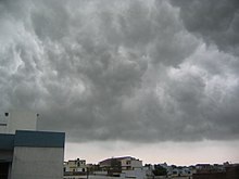 |
| Monsoon clouds over
Lucknow, Uttar Pradesh, India. |
Monsoon
A monsoon is a seasonal wind which lasts for several
months. The word was first used in English for the
seasonal rains in the Indian subcontinent. These rains
blow in from the Indian Ocean and Arabian Sea in the
southwest bringing heavy rainfall to the area.
Monsoons also occur in other regions such as in North
America, Sub-Saharan Africa, Brazil and East Asia.
Mechanism
The mechanism is simple: land heats up faster than
water. The temperature difference between the land and
sea can be as much as 20°C – land temperatures in India
can be hotter than 45°C, while the surrounding water in
the Bay of Bengal and the Arabian Sea remains in the low
20s. The heat absorbed by the land warms the air above
it. The hot air rises, and cooler ocean air rushes
inland to replace it. As it moves, it carries moisture
with it, releasing it over land as the summer monsoon
(also known as southwest monsoon).
The hot air over the land tends to rise, creating an
area of low pressure. This creates a steady wind blowing
toward the land, bringing the moist near-surface air
over the oceans with it. Rainfall is increased by the
moist ocean air being lifted upwards by mountains, as
with the Tibetan Plateau, and by surface heating. |
|
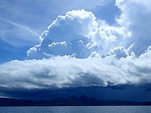 |
| Southeast African
monsoon clouds, over Mayotte island. |
Global monsoon
Africa (West African and
Southeast African)
The monsoon of western Sub-Saharan Africa is the result
of the seasonal shifts of the Intertropical Convergence
Zone and the great seasonal temperature and humidity
differences between the Sahara and the equatorial
Atlantic Ocean. It migrates northward from the
equatorial Atlantic in February, reaches western Africa
on or near June 22, then moves back to the south by
October. The dry, northeasterly trade winds, and their
more extreme form, the harmattan, are interrupted by the
northern shift in the ITCZ and resultant southerly,
rain-bearing winds during the summer. The semiarid Sahel
and Sudan depend upon this pattern for most of their
precipitation.
North America
The North American monsoon (NAM) occurs from late June
or early July into September, originating over Mexico
and spreading into the southwest United States by
mid-July. It affects Mexico along the Sierra Madre
Occidental as well as Arizona, New Mexico, Nevada, Utah,
Colorado, West Texas and California. It pushes as far
west as the Peninsular Ranges and Transverse Ranges of
Southern California, but rarely reaches the coastal
strip (a wall of desert thunderstorms only a half-hour's
drive away is a common summer sight from the sunny skies
along the coast during the monsoon). The North American
monsoon is known to many as the Summer, Southwest,
Mexican or Arizona monsoon. It is also sometimes called
the Desert monsoon as a large part of the affected area
are the Mojave and Sonoran deserts. However, it is
debatable whether the North and South American weather
patterns with incomplete wind reversal should be counted
as true monsoons. |
|
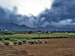 |
| Advancing monsoon
clouds and showers in Aralvaimozhy, near
Nagercoil, India. |
Asia
The Asian monsoons may be classified into a few
sub-systems, such as the Indian Subcontinental Monsoon
which affects the Indian subcontinent and surrounding
regions including Nepal, and the East Asian Monsoon
which affects southern China, Taiwan, Korea and parts of
Japan.
South Asian monsoon
Southwest monsoon
The southwestern summer monsoons occur from July through
September. The Thar Desert and adjoining areas of the
northern and central Indian subcontinent heat up
considerably during the hot summers. This causes a low
pressure area over the northern and central Indian
subcontinent. To fill this void, the moisture-laden
winds from the Indian Ocean rush into the subcontinent.
These winds, rich in moisture, are drawn towards the
Himalayas. The Himalayas act like a high wall, blocking
the winds from passing into Central Asia, and forcing
them to rise. As the clouds rise their temperature drops
and precipitation occurs. Some areas of the subcontinent
receive up to 10,000 mm (390 in) of rain annually.
The southwest monsoon is generally expected to begin
around the beginning of June and fade away by the end of
September. The moisture-laden winds on reaching the
southernmost point of the Indian Peninsula, due to its
topography, become divided into two parts: the Arabian
Sea Branch and the Bay of Bengal Branch.
The Arabian Sea Branch of the Southwest Monsoon first
hits the Western Ghats of the coastal state of Kerala,
India, thus making this area the first state in India to
receive rain from the Southwest Monsoon. This branch of
the monsoon moves northwards along the Western Ghats (Konkan
and Goa) with precipitation on coastal areas, west of
the Western Ghats. The eastern areas of the Western
Ghats do not receive much rain from this monsoon as the
wind does not cross the Western Ghats.
The Bay of Bengal Branch of Southwest Monsoon flows over
the Bay of Bengal heading towards North-East India and
Bengal, picking up more moisture from the Bay of Bengal.
The winds arrive at the Eastern Himalayas with large
amounts of rain. Mawsynram, situated on the southern
slopes of the Khasi Hills in Meghalaya, India, is one of
the wettest places on Earth. After the arrival at the
Eastern Himalayas, the winds turns towards the west,
travelling over the Indo-Gangetic Plain at a rate of
roughly 1–2 weeks per state, pouring rain all along its
way. June 1 is regarded as the date of onset of the
monsoon in India, as indicated by the arrival of the
monsoon in the southernmost state of Kerala.
The monsoon accounts for nearly 80% of the rainfall in
India. Indian agriculture (which accounts for 25% of the
GDP and employs 70% of the population) is heavily
dependent on the rains, for growing crops especially
like cotton, rice, oilseeds and coarse grains. A delay
of a few days in the arrival of the monsoon can badly
affect the economy, as evidenced in the numerous
droughts in India in the 1990s.
The monsoon is widely welcomed and appreciated by
city-dwellers as well, for it provides relief from the
climax of summer heat in June. However, the roads take a
battering every year. Often houses and streets are
waterlogged and slums are flooded despite drainage
systems. A lack of city infrastructure coupled with
changing climate patterns causes severe economic loss
including damage to property and loss of lives, as
evidenced in the 2005 flooding in Mumbai that brought
the city to a standstill. Bangladesh and certain regions
of India like Assam and West Bengal, also frequently
experience heavy floods during this season. Recently,
areas in India that used to receive scanty rainfall
throughout the year, like the Thar Desert, have
surprisingly ended up receiving floods due to the
prolonged monsoon season.
The influence of the Southwest Monsoon is felt as far
north as in China's Xinjiang. It is estimated that about
70% of all precipitation in the central part of the Tian
Shan Mountains falls during the three summer months,
when the region is under the monsoon influence; about
70% of that is directly of "cyclonic" (i.e.,
monsoon-driven) origin (as opposed to "local
convection").
Northeast monsoon
Around September, with the sun fast retreating south,
the northern land mass of the Indian subcontinent begins
to cool off rapidly. With this air pressure begins to
build over northern India, the Indian Ocean and its
surrounding atmosphere still holds its heat. This causes
cold wind to sweep down from the Himalayas and Indo-Gangetic
Plain towards the vast spans of the Indian Ocean south
of the Deccan peninsula. This is known as the Northeast
Monsoon or Retreating Monsoon.
While travelling towards the Indian Ocean, the dry cold
wind picks up some moisture from the Bay of Bengal and
pours it over peninsular India and parts of Sri Lanka.
Cities like Chennai, which get less rain from the
Southwest Monsoon, receive rain from this Monsoon. About
50% to 60% of the rain received by the state of Tamil
Nadu is from the Northeast Monsoon. In Southern Asia,
the northeastern monsoons take place from October to
December when the surface high-pressure system is
strongest. The jet stream in this region splits into the
southern subtropical jet and the polar jet. The
subtropical flow directs northeasterly winds to blow
across southern Asia, creating dry air streams which
produce clear skies over India. Meanwhile, a low
pressure system known as a monsoon trough develops over
South-East Asia and Australasia and winds are directed
toward Australia.
East Asian Monsoon
The East Asian monsoon affects large parts of
Indo-China, Philippines, China, Taiwan, Korea and Japan.
It is characterised by a warm, rainy summer monsoon and
a cold, dry winter monsoon. The rain occurs in a
concentrated belt that stretches east-west except in
East China where it is tilted east-northeast over Korea
and Japan. The seasonal rain is known as Meiyu in China,
Jangma in Korea, and Bai-u in Japan, with the latter two
resembling frontal rain.
The onset of the summer monsoon is marked by a period of
premonsoonal rain over South China and Taiwan in early
May. From May through August, the summer monsoon shifts
through a series of dry and rainy phases as the rain
belt moves northward, beginning over Indochina and the
South China Sea (May), to the Yangtze River Basin and
Japan (June) and finally to North China and Korea
(July). When the monsoon ends in August, the rain belt
moves back to South China. |
|
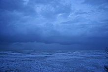 |
| Monsoonal squall
nears Darwin, Northern Territory, Australia. |
Australia
Also known as the Indo-Australian Monsoon. The rainy
season occurs from September to February and it is a
major source of energy for the Hadley circulation during
boreal winter. The Maritime Continent Monsoon and the
Australian Monsoon may be considered to be the same
system, the Indo-Australian Monsoon.
It is associated with the development of the Siberian
High and the movement of the heating maxima from the
Northern Hemisphere to the Southern Hemisphere.
North-easterly winds flow down Southeast Asia, are
turned north-westerly/westerly by Borneo topography
towards Australia. This forms a cyclonic circulation
vortex over Borneo, which together with descending cold
surges of winter air from higher latitudes, cause
significant weather phenomena in the region. Examples
are the formation of a rare low-latitude tropical storm
in 2001, Tropical Storm Vamei, and the devastating flood
of Jakarta in 2007.
The onset of the monsoon over the Maritime Continent
tends to follow the heating maxima down Vietnam and the
Malay Peninsula (September), to Sumatra, Borneo and the
Philippines (October), to Java, Sulawesi (November),
Irian Jaya and Northern Australia (December, January).
However, the monsoon is not a simple response to heating
but a more complex interaction of topography, wind and
sea, as demonstrated by its abrupt rather than gradual
withdrawal from the region. The Australian monsoon (the
"Wet") occurs in the southern summer when the monsoon
trough develops over Northern Australia. Over
three-quarters of annual rainfall in Northern Australia
falls during this time.
Europe
The European Monsoon (more commonly known as the return
of the westerlies) is the result of a resurgence of
westerly winds from the Atlantic, where they become
loaded with wind and rain. These westerly winds are a
common phenomenon during the European winter, but they
ease as spring approaches in late March and through
April and May. The winds pick up again in June, which is
why this phenomenon is also referred to as "the return
of the westerlies".
The rain usually arrives in two waves, at the beginning
of June and again in mid- to late June. The European
monsoon is not a monsoon in the traditional sense in
that it doesn't meet all the requirements to be
classified as such. Instead the return of the westerlies
is more regarded as a conveyor belt that delivers a
series of low pressure centres to Western Europe where
they create unsettled weather. These storms generally
feature significantly lower than average temperatures,
fierce rain or hail, thunder and strong winds.
The return of the westerlies affects Europe's Northern
Atlantic coastline, more precisely Ireland, Great
Britain, the Benelux countries, Western Germany,
Northern France and parts of Scandinavia. |
|
 Kiddle: Monsoon Kiddle: Monsoon
Wikipedia: Monsoon |
|
|
|
|
|
|
|
|
|
|
|
|
|
|
|
|
Search Fun Easy English |
|
|
|
|
|
|
|
|
|
|
|
|
|
|
|
About
Contact
Copyright
Resources
Site Map |
