|
|
| |
|
|
| |
|
|
|
|
| |
Ten Basic Clouds
Based on his observations, Luke Howard suggested there
were modifications (or combinations) of the core four
clouds between categories. He noticed that clouds often
have features of two or more categories; cirrus +
stratus, cumulus + stratus, etc. His research served as
the starting point for the ten basic types of clouds we
observe.
From the World Meteorological Organization's (WMO)
International Cloud Atlas, the official worldwide
standard for clouds, the following are definitions of
the ten basic cloud types. Divided by their height the
ten types of clouds are... |
High-Level Clouds
Cirrus (Ci),
Cirrocumulus (Cc), and
Cirrostratus (Cs) are high
level clouds. They are typically thin and white in
appearance, but can appear in a magnificent array of colors
when the sun is low on the horizon. |
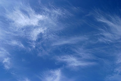
Cirrus (Ci)
Detached clouds in the form of white, delicate filaments,
mostly white patches or narrow bands. They may have a
fibrous (hair-like) and/or silky sheen appearance.
Cirrus clouds are always composed of ice crystals, and their
transparent character depends upon the degree of separation
of the crystals. As a rule, when these clouds cross the
sun's disk they hardly diminish its brightness. When they
are exceptionally thick they may veil its light and
obliterate its contour.
Before sunrise and after sunset, cirrus is often colored
bright yellow or red. These clouds are lit up long before
other clouds and fade out much later; some time after sunset
they become gray.
At all hours of the day Cirrus near the horizon is often of
a yellowish color; this is due to distance and to the great
thickness of air traversed by the rays of light. |
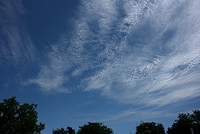
Cirrocumulus (Cc)
Thin, white patch, sheet, or layered of clouds without
shading. They are composed of very small elements in the
form of more or less regularly arranged grains or ripples.
Most of these elements have an apparent width of less than
one degree (approximately width of the little finger - at
arm's length).
In general, Cirrocumulus represents a degraded state of
cirrus and cirrostratus, both of which may change into it
and is an uncommon cloud. There will be a connection with
cirrus or cirrostratus and will show some characteristics of
ice crystal clouds. |
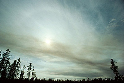
Cirrostratus (Cs)
Transparent, whitish veil clouds with a fibrous (hair-like)
or smooth appearance. A sheet of cirrostratus which is very
extensive, nearly always ends by covering the whole sky.
During the day, when the sun is sufficiently high above the
horizon, the sheet is never thick enough to prevent shadows
of objects on the ground.
A milky veil of fog (or thin Stratus) is distinguished from
a veil of Cirrostratus of a similar appearance by the halo
phenomena which the sun or the moon nearly always produces
in a layer of Cirrostratus. |
|
Mid-Level Clouds
Altocumulus (Ac),
Altostratus (As), and
Nimbostratus (Ns) are
mid-level clouds They are composed primarily of water
droplets. However, they can also be composed of ice
crystals when temperatures are low enough.
In Latin, alto means 'high' yet Altostratus and
Altocumulus clouds are classified as mid-level clouds.
'Alto' is used to distinguish these "high-level" clouds
and their low-level liquid-based counterpart clouds;
Stratus and Cumulus. |
Altocumulus (Ac)
White and/or gray patch, sheet or layered clouds, generally
composed of laminae (plates), rounded masses or rolls. They
may be partly fibrous or diffuse and may or may not be
merged.
Most of these regularly arranged small elements have an
apparent width of one to five degrees (larger than the
little finger and smaller than three fingers - at arm's
length).
When the edge or a thin semitransparent patch of altocumulus
passes in front of the sun or moon, a corona appears. This
colored ring has red on the outside and blue inside and
occurs within a few degrees of the sun or moon.
The most common mid cloud, more than one layer of
Altocumulus often appears at different levels at the same
time. Many times Altocumulus will appear with other cloud
types. |
Altostratus (As)
Gray or bluish cloud sheets or layers of striated or fibrous
clouds that totally or partially covers the sky. They are
thin enough to regularly reveal the sun as if seen through
ground glass.
Altostratus clouds do not produce a halo phenomenon nor are
the shadows of objects on the ground visible.
Sometime virga is seen hanging from Altostratus, and at
times may even reach the ground causing very light
precipitation. |
Nimbostratus (Ns)
Resulting from thickening Altostratus, This is a dark gray
cloud layer diffused by falling rain or snow. It is thick
enough throughout to blot out the sun. Also, low, ragged
clouds frequently occur beneath this cloud which sometimes
merges with its base.
The cloud base lowers as precipitation continues. Because of
the lowering base it is often erroneously called a low-level
cloud. Both Altostratus and Nimbostratus can extend into the
high level of clouds. |
|
Low-Level Clouds
Cumulus (Cu),
Stratocumulus (Sc),
Stratus (St), and
Cumulonimbus (Cb) are low
clouds composed of water droplets. Cumulonimbus, with
its strong vertical updraft, extends well into the the
high level of clouds. |
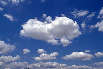
Cumulus (Cu)
Detached, generally dense clouds and with sharp outlines
that develop vertically in the form of rising mounds, domes
or towers with bulging upper parts often resembling a
cauliflower.
The sunlit parts of these clouds are mostly brilliant white
while their bases are relatively dark and horizontal.
Over land cumulus develops on days of clear skies, and is
due diurnal convection; it appears in the morning, grows,
and then more or less dissolves again toward evening. |
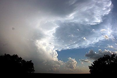
Cumulonimbus (Cb)
The thunderstorm cloud, this is a heavy and dense cloud in
the form of a mountain or huge tower. The upper portion is
usually smoothed, fibrous or striated and nearly always
flattened in the shape of an anvil or vast plume.
Under the base of this cloud which is often very dark, there
are often low ragged clouds that may or may not merge with
the base. They produce precipitation, which sometimes is in
the form of virga.
Cumulonimbus clouds also produce hail and tornadoes. |
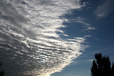
Stratocumulus (Sc)
Gray or whitish patch, sheet, or layered clouds which almost
always have dark tessellations (honeycomb appearance),
rounded masses or rolls. Except for virga they are
non-fibrous and may or may not be merged.
They also have regularly arranged small elements with an
apparent width of more than five degrees (three fingers - at
arm's length). |
Stratus (St)
A generally gray cloud layer with a uniform base which may,
if thick enough, produce drizzle, ice prisms, or snow
grains. When the sun is visible through this cloud, its
outline is clearly discernible.
Often when a layer of Stratus breaks up and dissipates blue
sky is seen.
Sometimes appearing as ragged sheets Stratus clouds do not
produce a halo phenomenon except, occasionally at very low
temperatures. |
|
Fast Facts
John "Dr. Lightning" Jensenius, retired NWS
Meteorologist, created a PDF "Cloud Book" called "Clouds
out my Window".
Clouds out my Window is available for free. At the end
of the book is a link to a Power Point template to make
your own "Clouds out my Window" book.
Clouds out my Window
- Click for a copy from Home Learning (PDF opens to a
new window) |
|
|
|
|
|
|
|
|
|
|
|
|
|
|
|
|
|
|
Search Fun Easy English |
|
|
|
|
|
|
|
|
|
|
|
|
|
|
|
About
Contact
Copyright
Resources
Site Map |