 |
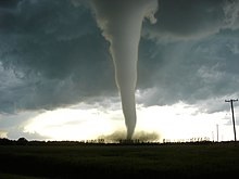
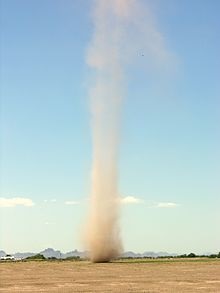
| A tornado near
Anadarko, Oklahoma, 1999. The funnel is the thin
tube reaching from the cloud to the ground. The
lower part of this tornado is surrounded by a
translucent dust cloud, kicked up by the
tornado's strong winds at the surface. The wind
of the tornado has a much wider radius than the
funnel itself. |
Characteristics
Size and shape
Most tornadoes take on the appearance of a narrow
funnel, a few hundred yards (meters) across, with a
small cloud of debris near the ground. Tornadoes may be
obscured completely by rain or dust. These tornadoes are
especially dangerous, as even experienced meteorologists
might not see them. Tornadoes can appear in many shapes
and sizes.
Appearance
Tornadoes can have a wide range of colors, depending on
the environment in which they form. Those that form in
dry environments can be nearly invisible, marked only by
swirling debris at the base of the funnel. Condensation
funnels that pick up little or no debris can be gray to
white. While traveling over a body of water (as a
waterspout), tornadoes can turn white or even blue.
Slow-moving funnels, which ingest a considerable amount
of debris and dirt, are usually darker, taking on the
color of debris. Tornadoes in the Great Plains can turn
red because of the reddish tint of the soil, and
tornadoes in mountainous areas can travel over
snow-covered ground, turning white.
Lighting conditions are a major factor in the appearance
of a tornado. A tornado which is "back-lit" (viewed with
the sun behind it) appears very dark. The same tornado,
viewed with the sun at the observer's back, may appear
gray or brilliant white. Tornadoes which occur near the
time of sunset can be many different colors, appearing
in hues of yellow, orange, and pink.
Dust kicked up by the winds of the parent thunderstorm,
heavy rain and hail, and the darkness of night are all
factors that can reduce the visibility of tornadoes.
Tornadoes occurring in these conditions are especially
dangerous, since only weather radar observations, or
possibly the sound of an approaching tornado, serve as
any warning to those in the storm's path. Most
significant tornadoes form under the storm's updraft
base, which is rain-free, making them visible. Also,
most tornadoes occur in the late afternoon, when the
bright sun can penetrate even the thickest clouds.
Night-time tornadoes are often illuminated by frequent
lightning.
Rotation
Tornadoes normally rotate cyclonically (when viewed from
above, this is counterclockwise in the northern
hemisphere and clockwise in the southern). While
large-scale storms always rotate cyclonically due to the
Coriolis effect, thunderstorms and tornadoes are so
small that the direct influence of the Coriolis effect
is unimportant, as indicated by their large Rossby
numbers. Supercells and tornadoes rotate cyclonically in
numerical simulations even when the Coriolis effect is
neglected. Low-level mesocyclones and tornadoes owe
their rotation to complex processes within the supercell
and ambient environment.
Sound and seismology
Tornadoes emit widely on the acoustics spectrum and the
sounds are caused by multiple mechanisms. Various sounds
of tornadoes have been reported, mostly related to
familiar sounds for the witness and generally some
variation of a whooshing roar. Popularly reported sounds
include a freight train, rushing rapids or waterfall, a
nearby jet engine, or combinations of these. Many
tornadoes are not audible from much distance; the nature
of and the propagation distance of the audible sound
depends on atmospheric conditions and topography.
Electromagnetic, lightning,
and other effects
Tornadoes emit on the electromagnetic spectrum, with
sferics and E-field effects detected. There are observed
correlations between tornadoes and patterns of
lightning. Tornadic storms do not contain more lightning
than other storms and some tornadic cells never produce
lightning at all. More often than not, overall
cloud-to-ground (CG) lightning activity decreases as a
tornado touches the surface and returns to the baseline
level when the tornado dissipates. In many cases,
intense tornadoes and thunderstorms exhibit an increased
and anomalous dominance of positive polarity CG
discharges. Electromagnetics and lightning have little
or nothing to do directly with what drives tornadoes
(tornadoes are basically a thermodynamic phenomenon),
although there are likely connections with the storm and
environment affecting both phenomena. |
|
 |
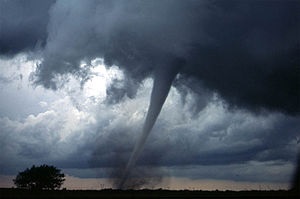
| A sequence of images
showing the birth of a tornado. First, the
rotating cloud base lowers. This lowering
becomes a funnel, which continues descending
while winds build near the surface, kicking up
dust and debris and causing damage. As the
pressure continues to drop, the visible funnel
extends to the ground. This tornado, near
Dimmitt, Texas, was one of the best-observed
violent tornadoes in history. |
Life cycle
Supercell relationship
Tornadoes often develop from a class of thunderstorms
known as supercells. Supercells contain mesocyclones, an
area of organized rotation a few miles up in the
atmosphere, usually 1–6 miles (1.6–9.7 kilometres)
across. Most intense tornadoes (EF3 to EF5 on the
Enhanced Fujita Scale) develop from supercells. In
addition to tornadoes, very heavy rain, frequent
lightning, strong wind gusts, and hail are common in
such storms.
Most tornadoes from supercells follow a recognizable
life cycle which begins when increasing rainfall drags
with it an area of quickly descending air known as the
rear flank downdraft (RFD). This downdraft accelerates
as it approaches the ground, and drags the supercell's
rotating mesocyclone towards the ground with it.
Formation
As the mesocyclone lowers below the cloud base, it
begins to take in cool, moist air from the downdraft
region of the storm. The convergence of warm air in the
updraft and cool air causes a rotating wall cloud to
form. The RFD also focuses the mesocyclone's base,
causing it to draw air from a smaller and smaller area
on the ground. As the updraft intensifies, it creates an
area of low pressure at the surface. This pulls the
focused mesocyclone down, in the form of a visible
condensation funnel. As the funnel descends, the RFD
also reaches the ground, fanning outward and creating a
gust front that can cause severe damage a considerable
distance from the tornado. Usually, the funnel cloud
begins causing damage on the ground (becoming a tornado)
within a few minutes of the RFD reaching the ground.
Maturity
Initially, the tornado has a good source of warm, moist
air flowing inward to power it, and it grows until it
reaches the "mature stage". This can last from a few
minutes to more than an hour, and during that time a
tornado often causes the most damage, and in rare cases
can be more than one mile (1.6 km) across. The low
pressured atmosphere at the base of the tornado is
essential to the endurance of the system. Meanwhile, the
RFD, now an area of cool surface winds, begins to wrap
around the tornado, cutting off the inflow of warm air
which previously fed the tornado. |
 |
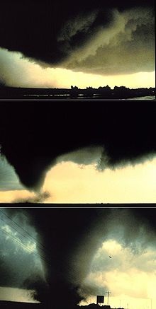
| Composite of eight
images shot in sequence as a tornado formed in
Kansas in 2016. |
Dissipation
As the RFD completely wraps around and chokes off the
tornado's air supply, the vortex begins to weaken,
becoming thin and rope-like. This is the "dissipating
stage", often lasting no more than a few minutes, after
which the tornado ends. During this stage the shape of
the tornado becomes highly influenced by the winds of
the parent storm, and can be blown into fantastic
patterns. Even though the tornado is dissipating, it is
still capable of causing damage. The storm is
contracting into a rope-like tube and, due to
conservation of angular momentum, winds can increase at
this point.
As the tornado enters the dissipating stage, its
associated mesocyclone often weakens as well, as the
rear flank downdraft cuts off the inflow powering it.
Sometimes, in intense supercells, tornadoes can develop
cyclically. As the first mesocyclone and associated
tornado dissipate, the storm's inflow may be
concentrated into a new area closer to the center of the
storm and possibly feed a new mesocyclone. If a new
mesocyclone develops, the cycle may start again,
producing one or more new tornadoes. Occasionally, the
old (occluded) mesocyclone and the new mesocyclone
produce a tornado at the same time.
Although this is a widely accepted theory for how most
tornadoes form, live, and die, it does not explain the
formation of smaller tornadoes, such as landspouts,
long-lived tornadoes, or tornadoes with multiple
vortices. These each have different mechanisms which
influence their development—however, most tornadoes
follow a pattern similar to this one. |
 |
| A dust devil in
Arizona. |
Types
Multiple vortex
A multiple-vortex tornado is a type of tornado in which
two or more columns of spinning air rotate about their
own axes and at the same time revolve around a common
center. A multi-vortex structure can occur in almost any
circulation, but is very often observed in intense
tornadoes. These vortices often create small areas of
heavier damage along the main tornado path. This is a
phenomenon that is distinct from a satellite tornado,
which is a smaller tornado which forms very near a
large, strong tornado contained within the same
mesocyclone. The satellite tornado may appear to "orbit"
the larger tornado (hence the name), giving the
appearance of one, large multi-vortex tornado. However,
a satellite tornado is a distinct circulation, and is
much smaller than the main funnel.
Waterspout
A waterspout is defined by the National Weather Service
as a tornado over water. However, researchers typically
distinguish "fair weather" waterspouts from tornadic
(i.e. associated with a mesocyclone) waterspouts. Fair
weather waterspouts are less severe but far more common,
and are similar to dust devils and landspouts. They form
at the bases of cumulus congestus clouds over tropical
and subtropical waters. They have relatively weak winds,
smooth laminar walls, and typically travel very slowly.
They occur most commonly in the Florida Keys and in the
northern Adriatic Sea. In contrast, tornadic waterspouts
are stronger tornadoes over water. They form over water
similarly to mesocyclonic tornadoes, or are stronger
tornadoes which cross over water. Since they form from
severe thunderstorms and can be far more intense,
faster, and longer-lived than fair weather waterspouts,
they are more dangerous. In official tornado statistics,
waterspouts are generally not counted unless they affect
land, though some European weather agencies count
waterspouts and tornadoes together.
Landspout
A landspout, or dust-tube tornado, is a tornado not
associated with a mesocyclone. The name stems from their
characterization as a "fair weather waterspout on land".
Waterspouts and landspouts share many defining
characteristics, including relative weakness, short
lifespan, and a small, smooth condensation funnel which
often does not reach the surface. Landspouts also create
a distinctively laminar cloud of dust when they make
contact with the ground, due to their differing
mechanics from true mesoform tornadoes. Though usually
weaker than classic tornadoes, they can produce strong
winds which could cause serious damage.
Similar circulations
Gustnado
A gustnado, or gust front tornado, is a small, vertical
swirl associated with a gust front or downburst. Because
they are not connected with a cloud base, there is some
debate as to whether or not gustnadoes are tornadoes.
They are formed when fast moving cold, dry outflow air
from a thunderstorm is blown through a mass of
stationary, warm, moist air near the outflow boundary,
resulting in a "rolling" effect (often exemplified
through a roll cloud). If low level wind shear is strong
enough, the rotation can be turned vertically or
diagonally and make contact with the ground. The result
is a gustnado. They usually cause small areas of heavier
rotational wind damage among areas of straight-line wind
damage.
Dust devil
A dust devil (also known as a whirlwind) resembles a
tornado in that it is a vertical swirling column of air.
However, they form under clear skies and are no stronger
than the weakest tornadoes. They form when a strong
convective updraft is formed near the ground on a hot
day. If there is enough low level wind shear, the column
of hot, rising air can develop a small cyclonic motion
that can be seen near the ground. They are not
considered tornadoes because they form during fair
weather and are not associated with any clouds. However,
they can, on occasion, result in major damage.
Fire whirls
Small-scale, tornado-like circulations can occur near
any intense surface heat source. Those that occur near
intense wildfires are called fire whirls. They are not
considered tornadoes, except in the rare case where they
connect to a pyrocumulus or other cumuliform cloud
above. Fire whirls usually are not as strong as
tornadoes associated with thunderstorms. They can,
however, produce significant damage.
Steam devils
A steam devil is a rotating updraft between 50 and 200
meters wide that involves steam or smoke. These
formations do not involve high wind speeds, only
completing a few rotations per minute. Steam devils are
very rare. They most often form from smoke issuing from
a power plant's smokestack. Hot springs and deserts may
also be suitable locations for a tighter,
faster-rotating steam devil to form. The phenomenon can
occur over water, when cold arctic air passes over
relatively warm water. |
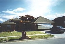 |
| A house displaying
EF1 damage. The roof and garage door have been
damaged, but walls and supporting structures are
still intact. |
Intensity and
damage
The Fujita scale and the Enhanced Fujita Scale rate
tornadoes by damage caused. The Enhanced Fujita (EF)
Scale was an update to the older Fujita scale, by expert
elicitation, using engineered wind estimates and better
damage descriptions. The EF Scale was designed so that a
tornado rated on the Fujita scale would receive the same
numerical rating, and was implemented starting in the
United States in 2007. An EF0 tornado will probably
damage trees but not substantial structures, whereas an
EF5 tornado can rip buildings off their foundations
leaving them bare and even deform large skyscrapers. The
similar TORRO scale ranges from a T0 for extremely weak
tornadoes to T11 for the most powerful known tornadoes.
Doppler weather radar data, photogrammetry, and ground
swirl patterns (cycloidal marks) may also be analyzed to
determine intensity and award a rating.
Tornadoes vary in intensity regardless of shape, size,
and location, though strong tornadoes are typically
larger than weak tornadoes. The association with track
length and duration also varies, although longer track
tornadoes tend to be stronger. In the case of violent
tornadoes, only a small portion of the path is of
violent intensity, most of the higher intensity from
subvortices.
In the United States, 80% of tornadoes are EF0 and EF1
(T0 through T3) tornadoes. The rate of occurrence drops
off quickly with increasing strength—less than 1% are
violent tornadoes (EF4, T8 or stronger). Outside Tornado
Alley, and North America in general, violent tornadoes
are extremely rare. This is apparently mostly due to the
lesser number of tornadoes overall, as research shows
that tornado intensity distributions are fairly similar
worldwide. A few significant tornadoes occur annually in
Europe, Asia, southern Africa, and southeastern South
America. |
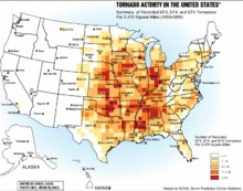 |
| Intense tornado
activity in the United States. The
darker-colored areas denote the area commonly
referred to as Tornado Alley. |
Climatology
The United States has the most tornadoes of any country,
nearly four times more than estimated in all of Europe,
excluding waterspouts. This is mostly due to the unique
geography of the continent. North America is a large
continent that extends from the tropics north into
arctic areas, and has no major east–west mountain range
to block air flow between these two areas. In the middle
latitudes, where most tornadoes of the world occur, the
Rocky Mountains block moisture and buckle the
atmospheric flow, forcing drier air at mid-levels of the
troposphere due to downsloped winds, and causing the
formation of a low pressure area downwind to the east of
the mountains. Increased westerly flow off the Rockies
force the formation of a dry line when the flow aloft is
strong, while the Gulf of Mexico fuels abundant
low-level moisture in the southerly flow to its east.
This unique topography allows for frequent collisions of
warm and cold air, the conditions that breed strong,
long-lived storms throughout the year. A large portion
of these tornadoes form in an area of the central United
States known as Tornado Alley. This area extends into
Canada, particularly Ontario and the Prairie Provinces,
although southeast Quebec, the interior of British
Columbia, and western New Brunswick are also
tornado-prone. Tornadoes also occur across northeastern
Mexico.
The United States averages about 1,200 tornadoes per
year, followed by Canada, averaging 62 reported per
year. NOAA's has a higher average 100 per year in
Canada. The Netherlands has the highest average number
of recorded tornadoes per area of any country (more than
20, or 0.0013 per sq mi (0.00048 per km2), annually),
followed by the UK (around 33, or 0.00035 per sq mi
(0.00013 per km2), per year), although those are of
lower intensity, briefer and cause minor damage.
Tornadoes kill an average of 179 people per year in
Bangladesh, the most in the world. Reasons for this
include the region's high population density, poor
construction quality, and lack of tornado safety
knowledge. Other areas of the world that have frequent
tornadoes include South Africa, the La Plata Basin area,
portions of Europe, Australia and New Zealand, and far
eastern Asia.
Tornadoes are most common in spring and least common in
winter, but tornadoes can occur any time of year that
favorable conditions occur. Spring and fall experience
peaks of activity as those are the seasons when stronger
winds, wind shear, and atmospheric instability are
present. Tornadoes are focused in the right front
quadrant of landfalling tropical cyclones, which tend to
occur in the late summer and autumn. Tornadoes can also
be spawned as a result of eyewall mesovortices, which
persist until landfall.
Tornado occurrence is highly dependent on the time of
day, because of solar heating. Worldwide, most tornadoes
occur in the late afternoon, between 3 pm and 7 pm local
time, with a peak near 5 pm. Destructive tornadoes can
occur at any time of day. The Gainesville Tornado of
1936, one of the deadliest tornadoes in history,
occurred at 8:30 am local time.
The United Kingdom has the highest incidence of
tornadoes per unit area of land in the world. Unsettled
conditions and weather fronts transverse the British
Isles at all times of the years, and are responsible for
spawning the tornadoes, which consequently form at all
times of the year. The United Kingdom has at least 34
tornadoes per year and possibly as many as 50. Most
tornadoes in the United Kingdom are weak, but they are
occasionally destructive. For example, the Birmingham
tornado of 2005 and the London tornado of 2006 both
registered F2 on the Fujita scale and both caused
significant damage and injury.
Detection
Rigorous attempts to warn of tornadoes began in the
United States in the mid-20th century. Before the 1950s,
the only method of detecting a tornado was by someone
seeing it on the ground. Often, news of a tornado would
reach a local weather office after the storm. However,
with the advent of weather radar, areas near a local
office could get advance warning of severe weather. The
first public tornado warnings were issued in 1950 and
the first tornado watches and convective outlooks came
about in 1952. In 1953, it was confirmed that hook
echoes were associated with tornadoes. By recognizing
these radar signatures, meteorologists could detect
thunderstorms probably producing tornadoes from several
miles away. |
|
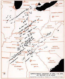 |
| A map of the tornado
paths in the Super Outbreak (April 3–4, 1974). |
Extremes
The tornado which holds most records in history was the
Tri-State Tornado, which roared through parts of
Missouri, Illinois, and Indiana on March 18, 1925. It
was likely an F5, though tornadoes were not ranked on
any scale in that era. It holds records for longest path
length (219 miles; 352 km), longest duration (about 3.5
hours), and fastest forward speed for a significant
tornado (73 mph; 117 km/h) anywhere on Earth. In
addition, it is the deadliest single tornado in United
States history (695 dead). The tornado was also the
costliest tornado in history at the time (unadjusted for
inflation), but in the years since has been surpassed by
several others if population changes over time are not
considered. When costs are normalized for wealth and
inflation, it ranks third today.
The deadliest tornado in world history was the
Daultipur-Salturia Tornado in Bangladesh on April 26,
1989, which killed approximately 1,300 people.
Bangladesh has had at least 19 tornadoes in its history
that killed more than 100 people, almost half of the
total in the rest of the world.
The most extensive tornado outbreak on record was the
2011 Super Outbreak, which spawned 360 confirmed
tornadoes over the southeastern United States, 216 of
them within a single 24-hour period. The previous record
was the 1974 Super Outbreak which spawned 148 tornadoes.
While direct measurement of the most violent tornado
wind speeds is nearly impossible, since conventional
anemometers would be destroyed by the intense winds and
flying debris, some tornadoes have been scanned by
mobile Doppler radar units, which can provide a good
estimate of the tornado's winds. The highest wind speed
ever measured in a tornado, which is also the highest
wind speed ever recorded on the planet, is 301 ± 20 mph
(484 ± 32 km/h) in the F5 Bridge Creek-Moore, Oklahoma,
tornado which killed 36 people. The reading was taken
about 100 feet (30 m) above the ground.
Storms that produce tornadoes can feature intense
updrafts, sometimes exceeding 150 mph (240 km/h). Debris
from a tornado can be lofted into the parent storm and
carried a very long distance. A tornado which affected
Great Bend, Kansas, in November 1915, was an extreme
case, where a "rain of debris" occurred 80 miles (130
km) from the town, a sack of flour was found 110 miles
(180 km) away, and a cancelled check from the Great Bend
bank was found in a field outside of Palmyra, Nebraska,
305 miles (491 km) to the northeast. Waterspouts and
tornadoes have been advanced as an explanation for
instances of raining fish and other animals. |
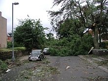 |
| Damage from the
Birmingham tornado of 2005. An unusually strong
example of a tornado event in the United
Kingdom, the Birmingham Tornado resulted in 19
injuries, mostly from falling trees. |
Safety
Though tornadoes can strike in an instant, there are
precautions and preventative measures that can be taken
to increase the chances of survival. Authorities such as
the Storm Prediction Center advise having a
pre-determined plan should a tornado warning be issued.
When a warning is issued, going to a basement or an
interior first-floor room of a sturdy building greatly
increases chances of survival. In tornado-prone areas,
many buildings have underground storm cellars, which
have saved thousands of lives.
Some countries have meteorological agencies which
distribute tornado forecasts and increase levels of
alert of a possible tornado (such as tornado watches and
warnings in the United States and Canada). Weather
radios provide an alarm when a severe weather advisory
is issued for the local area, mainly available only in
the United States. Unless the tornado is far away and
highly visible, meteorologists advise that drivers park
their vehicles far to the side of the road (so as not to
block emergency traffic), and find a sturdy shelter. If
no sturdy shelter is nearby, getting low in a ditch is
the next best option. Highway overpasses are one of the
worst places to take shelter during tornadoes, as the
constricted space can be subject to increased wind speed
and funneling of debris underneath the overpass. |
 |
| The 1999 Salt Lake
City tornado disproved several misconceptions,
including the idea that tornadoes cannot occur
in cities. |
Myths and
misconceptions
Folklore often identifies a green sky with tornadoes,
and though the phenomenon may be associated with severe
weather, there is no evidence linking it specifically
with tornadoes. It is often thought that opening windows
will lessen the damage caused by the tornado. While
there is a large drop in atmospheric pressure inside a
strong tornado, it is unlikely that the pressure drop
would be enough to cause the house to explode. Opening
windows may actually increase the severity of the
tornado's damage. A violent tornado can destroy a house
whether its windows are open or closed.
Another commonly held misconception is that highway
overpasses provide adequate shelter from tornadoes. This
belief is partly inspired by widely circulated video
captured during the 1991 tornado outbreak near Andover,
Kansas, where a news crew and several other people take
shelter under an overpass on the Kansas Turnpike and
safely ride out a tornado as it passes by. However, a
highway overpass is a dangerous place during a tornado,
and the subjects of the video remained safe due to an
unlikely combination of events: the storm in question
was a weak tornado, the tornado did not directly strike
the overpass, and the overpass itself was of a unique
design. Due to the Venturi effect, tornadic winds are
accelerated in the confined space of an overpass.
Indeed, in the 1999 Oklahoma tornado outbreak of May 3,
1999, three highway overpasses were directly struck by
tornadoes, and at each of the three locations there was
a fatality, along with many life-threatening injuries.
By comparison, during the same tornado outbreak, more
than 2,000 homes were completely destroyed and another
7,000 damaged, and yet only a few dozen people died in
their homes.
An old belief is that the southwest corner of a basement
provides the most protection during a tornado. The
safest place is the side or corner of an underground
room opposite the tornado's direction of approach
(usually the northeast corner), or the central-most room
on the lowest floor. Taking shelter in a basement, under
a staircase, or under a sturdy piece of furniture such
as a workbench further increases chances of survival.
There are areas which people believe to be protected
from tornadoes, whether by being in a city, near a major
river, hill, or mountain, or even protected by
supernatural forces. Tornadoes have been known to cross
major rivers, climb mountains, affect valleys, and have
damaged several city centers. As a general rule, no area
is safe from tornadoes, though some areas are more
susceptible than others. |
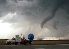 |
| A Doppler on Wheels
unit observing a tornado near Attica, Kansas. |
Ongoing research
Meteorology is a relatively young science and the study
of tornadoes is newer still. Although researched for
about 140 years and intensively for around 60 years,
there are still aspects of tornadoes which remain a
mystery. Scientists have a fairly good understanding of
the development of thunderstorms and mesocyclones, and
the meteorological conditions conducive to their
formation. However, the step from supercell, or other
respective formative processes, to tornadogenesis and
the prediction of tornadic vs. non-tornadic mesocyclones
is not yet well known and is the focus of much research. |
|
|
|