 |
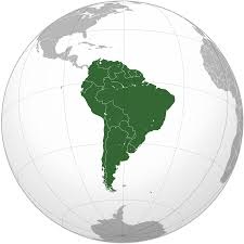
| Map showing location
of South America. |
South America
South America is a continent entirely in the Western
Hemisphere and mostly in the Southern Hemisphere, with a
relatively small portion in the Northern Hemisphere. It
can also be described as a southern subcontinent of the
Americas. The reference to South America instead of
other regions (like Latin America or the Southern Cone)
has increased in recent decades due to changing
geopolitical dynamics (in particular, the rise of
Brazil).
It is bordered on the west by the Pacific Ocean and on
the north and east by the Atlantic Ocean; North America
and the Caribbean Sea lie to the northwest. It includes
twelve sovereign states: Argentina, Bolivia, Brazil,
Chile, Colombia, Ecuador, Guyana, Paraguay, Peru,
Suriname, Uruguay, and Venezuela; one region of France:
French Guiana; and dependencies of sovereign state. The
major dependency are the Falkland Islands, a British
Overseas Territory. In addition, the ABC islands of the
Kingdom of the Netherlands, Ascension Island (dependency
of Saint Helena, Ascension and Tristan da Cunha, a
British Overseas Territory), Bouvet Island (dependency
of Norway), Panama, South Georgia and the South Sandwich
Islands (a British Overseas Territory), and Trinidad and
Tobago may also be considered parts of South America.
South America has an area of 17,840,000 square
kilometers (6,890,000 sq mi). Its population as of 2018
has been estimated at more than 423 million. South
America ranks fourth in area (after Asia, Africa, and
North America) and fifth in population (after Asia,
Africa, Europe, and North America). Brazil is by far the
most populous South American country, with more than
half of the continent's population, followed by
Colombia, Argentina, Venezuela and Peru. In recent
decades, Brazil has also generated half of the
continent's GDP and has become the first regional power.
Most of the population lives near the continent's
western or eastern coasts while the interior and the far
south are sparsely populated. The geography of western
South America is dominated by the Andes mountains; in
contrast, the eastern part contains both highland
regions and vast lowlands where rivers such as the
Amazon, Orinoco, and Paraná flow. Most of the continent
lies in the tropics.
The continent's cultural and ethnic outlook has its
origin with the interaction of indigenous peoples with
European conquerors and immigrants and, more locally,
with African slaves. Given a long history of
colonialism, the overwhelming majority of South
Americans speak Portuguese or Spanish, and societies and
states reflect Western traditions. Relative to Europe,
Asia and Africa, 20th-century South America has been a
peaceful continent with few wars. |
|
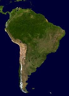 |
| A composite relief
image of South America. |
Geography
South America occupies the southern portion of the
Americas. The continent is generally delimited on the
northwest by the Darién watershed along the
Colombia–Panama border, although some may consider the
border instead to be the Panama Canal. Geopolitically
and geographically, all of Panama – including the
segment east of the Panama Canal in the isthmus – is
typically included in North America alone and among the
countries of Central America. Almost all of mainland
South America sits on the South American Plate.
South America is home to the world's highest
uninterrupted waterfall, Angel Falls in Venezuela; the
highest single drop waterfall Kaieteur Falls in Guyana;
the largest river by volume, the Amazon River; the
longest mountain range, the Andes (whose highest
mountain is Aconcagua at 6,962 m or 22,841 ft); the
driest non-polar place on earth, the Atacama Desert; the
wettest place on earth, López de Micay in Colombia; the
largest rainforest, the Amazon rainforest; the highest
capital city, La Paz, Bolivia; the highest commercially
navigable lake in the world, Lake Titicaca; and,
excluding research stations in Antarctica, the world's
southernmost permanently inhabited community, Puerto
Toro, Chile.
South America's major mineral resources are gold,
silver, copper, iron ore, tin, and petroleum. These
resources found in South America have brought high
income to its countries especially in times of war or of
rapid economic growth by industrialized countries
elsewhere. However, the concentration in producing one
major export commodity often has hindered the
development of diversified economies. The fluctuation in
the price of commodities in the international markets
has led historically to major highs and lows in the
economies of South American states, often causing
extreme political instability. This is leading to
efforts to diversify production to drive away from
staying as economies dedicated to one major export. |
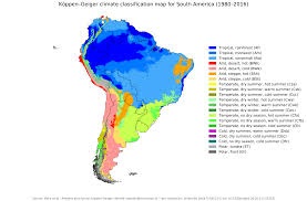 |
| Köppen-Geiger
climate classification map for South America. |
Climate
The distribution of the average temperatures in the
region presents a constant regularity from the 30° of
latitude south, when the isotherms tend, more and more,
to be confused with the degrees of latitude.
In temperate latitudes, winters and summers are milder
than in North America. This is because the most
extensive part of the continent is in the equatorial
zone (the region has more areas of equatorial plains
than any other region.), therefore giving the Southern
Cone more oceanic influence, which moderates year round
temperatures.
The average annual temperatures in the Amazon basin
oscillate around 27 °C (81 °F), with low thermal
amplitudes and high rainfall indices. Between the
Maracaibo Lake and the mouth of the Orinoco,
predominates an equatorial climate of the type
Congolese, that also includes parts of the Brazilian
territory.
The east-central Brazilian plateau has a humid and warm
tropical climate. The northern and eastern parts of the
Argentine pampas have a humid subtropical climate with
dry winters and humid summers of the Chinese type, while
the western and eastern ranges have a subtropical
climate of the dinaric type. At the highest points of
the Andean region, climates are colder than the ones
occurring at the highest point of the Norwegian fjords.
In the Andean plateaus, the warm climate prevails,
although it is tempered by the altitude, while in the
coastal strip, there is an equatorial climate of the
Guinean type. From this point until the north of the
Chilean coast appear, successively, Mediterranean
oceanic climate, temperate of the Breton type and,
already in Tierra del Fuego, cold climate of the
Siberian type.
The distribution of rainfall is related to the regime of
winds and air masses. In most of the tropical region
east of the Andes, winds blowing from the northeast,
east and southeast carry moisture from the Atlantic,
causing abundant rainfall. However, due to a
consistently strong wind shear and a weak Intertropical
Convergence Zone, South Atlantic tropical cyclones are
rare. In the Orinoco Llanos and in the Guianas Plateau,
the precipitation levels go from moderate to high. The
Pacific coast of Colombia and northern Ecuador are rainy
regions, with Chocó in Colombia being the most rainy
place in the world along with the northern slopes of
Indian Himalayas. The Atacama Desert, along this stretch
of coast, is one of the driest regions in the world. The
central and southern parts of Chile are subject to
extratropical cyclones, and most of the Argentine
Patagonia is desert. In the Pampas of Argentina, Uruguay
and South of Brazil the rainfall is moderate, with rains
well distributed during the year. The moderately dry
conditions of the Chaco oppose the intense rainfall of
the eastern region of Paraguay. In the semiarid coast of
the Brazilian Northeast the rains are linked to a
monsoon regime.
Important factors in the determination of climates are
sea currents, such as the current Humboldt and
Falklands. The equatorial current of the South Atlantic
strikes the coast of the Northeast and there is divided
into two others: the current of Brazil and a coastal
current that flows to the northwest towards the
Antilles, where there it moves towards northeast course
thus forming the most Important and famous ocean current
in the world, the Gulf Stream. |
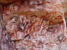 |
| The prehistoric
Cueva de las Manos, or "Cave of the Hands", in
Argentina. |
History
Prehistory
South America is believed to have been joined with
Africa from the late Paleozoic Era to the early Mesozoic
Era, until the supercontinent Pangaea began to rift and
break apart about 225 million years ago. Therefore,
South America and Africa share similar fossils and rock
layers.
South America is thought to have been first inhabited by
humans when people were crossing the Bering Land Bridge
(now the Bering Strait) at least 15,000 years ago from
the territory that is present-day Russia. They migrated
south through North America, and eventually reached
South America through the Isthmus of Panama.
The first evidence for the existence of the human race
in South America dates back to about 9000 BC, when
squashes, chili peppers and beans began to be cultivated
for food in the highlands of the Amazon Basin. Pottery
evidence further suggests that manioc, which remains a
staple food today, was being cultivated as early as 2000
BC.
By 2000 BC, many agrarian communities had been settled
throughout the Andes and the surrounding regions.
Fishing became a widespread practice along the coast,
helping establish fish as a primary source of food.
Irrigation systems were also developed at this time,
which aided in the rise of an agrarian society.
South American cultures began domesticating llamas,
vicuñas, guanacos, and alpacas in the highlands of the
Andes circa 3500 BC. Besides their use as sources of
meat and wool, these animals were used for
transportation of goods. |
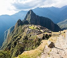 |
| The Inca estate of
Machu Picchu, Peru is one of the New Seven
Wonders of the World. |
Pre-Columbian
civilizations
The rise of plant growing and the subsequent appearance
of permanent human settlements allowed for the multiple
and overlapping beginnings of civilizations in South
America.
One of the earliest known South American civilizations
was at Norte Chico, on the central Peruvian coast.
Though a pre-ceramic culture, the monumental
architecture of Norte Chico is contemporaneous with the
pyramids of Ancient Egypt. Norte Chico governing class
established a trade network and developed agriculture
then followed by Chavín by 900 BC, according to some
estimates and archaeological finds. Artifacts were found
at a site called Chavín de Huantar in modern Peru at an
elevation of 3,177 meters (10,423 ft). Chavín
civilization spanned 900 BC to 300 BC.
In the central coast of Peru, around the beginning of
the 1st millennium AD, Moche (100 BC – 700 AD, at the
northern coast of Peru), Paracas and Nazca (400 BC – 800
AD, Peru) cultures flourished with centralized states
with permanent militia improving agriculture through
irrigation and new styles of ceramic art. At the
Altiplano, Tiahuanaco or Tiwanaku (100 BC – 1200 AD,
Bolivia) managed a large commercial network based on
religion.
Around the 7th century, both Tiahuanaco and Wari or
Huari Empire (600–1200, Central and northern Peru)
expanded its influence to all the Andean region,
imposing the Huari urbanism and Tiahuanaco religious
iconography.
The Muisca were the main indigenous civilization in what
is now Colombia. They established the Muisca
Confederation of many clans, or cacicazgos, that had a
free trade network among themselves. They were
goldsmiths and farmers.
Other important Pre-Columbian cultures include: the
Cañaris (in south central Ecuador), Chimú Empire
(1300–1470, Peruvian northern coast), Chachapoyas, and
the Aymaran kingdoms (1000–1450, Western Bolivia and
southern Peru). Holding their capital at the great city
of Cusco, the Inca civilization dominated the Andes
region from 1438 to 1533. Known as Tawantin suyu, and
"the land of the four regions," in Quechua, the Inca
Empire was highly distinct and developed. Inca rule
extended to nearly a hundred linguistic or ethnic
communities, some nine to fourteen million people
connected by a 25,000 kilometer road system. Cities were
built with precise, unmatched stonework, constructed
over many levels of mountain terrain. Terrace farming
was a useful form of agriculture.
The Mapuche in Central and Southern Chile resisted the
European and Chilean settlers, waging the Arauco War for
more than 300 years. |
|
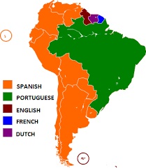 |
| Main European
languages spoken in South America. |
Demographics
South America has a population of over 428 million
people.There are several areas of sparse demographics
such as tropical forests, the Atacama Desert and the icy
portions of Patagonia. On the other hand, the continent
presents regions of high population density, such as the
great urban centers. The population is formed by
descendants of Europeans (mainly Spaniards, Portuguese
and Italians), Africans and Amerindians. There is a high
percentage of Mestizos that vary greatly in composition
by place. There is also a minor population of
Asians,[further explanation needed] especially in
Brazil, Peru, and Argentina. The two main languages are
by far Spanish and Portuguese, followed by English,
French and Dutch in smaller numbers.
Language
Spanish and Portuguese are the most spoken languages in
South America, with approximately 200 million speakers
each. Spanish is the official language of most
countries, along with other native languages in some
countries. Portuguese is the official language of
Brazil. Dutch is the official language of Suriname;
English is the official language of Guyana, although
there are at least twelve other languages spoken in the
country, including Portuguese, Chinese, Hindustani and
several native languages. English is also spoken in the
Falkland Islands. French is the official language of
French Guiana and the second language in Amapá, Brazil.
Indigenous languages of South America include Quechua in
Peru, Bolivia, Ecuador, Chile and Colombia; Wayuunaiki
in northern Colombia (La Guajira) and northwestern
Venezuela (Zulia); Guaraní in Paraguay and, to a much
lesser extent, in Bolivia; Aymara in Bolivia, Peru, and
less often in Chile; and Mapudungun is spoken in certain
pockets of southern Chile. At least three South American
indigenous languages (Quechua, Aymara, and Guarani) are
recognized along with Spanish as national languages.
Other languages found in South America include
Hindustani and Javanese in Suriname; Italian in
Argentina, Brazil, Uruguay and Venezuela; and German in
certain pockets of Argentina and Brazil. German is also
spoken in many regions of the southern states of Brazil,
Riograndenser Hunsrückisch being the most widely spoken
German dialect in the country; among other Germanic
dialects, a Brazilian form of East Pomeranian is also
well represented and is experiencing a revival. Welsh
remains spoken and written in the historic towns of
Trelew and Rawson in the Argentine Patagonia. There are
also small clusters of Japanese-speakers in Brazil,
Colombia and Peru. Arabic speakers, often of Lebanese,
Syrian, or Palestinian descent, can be found in Arab
communities in Argentina, Colombia, Brazil, Venezuela
and in Paraguay.
Wildlife
South America is home to a large variety of animal life.
These include animals such as jaguars, macaws, monkeys,
anacondas, llamas, piranhas, toucans, tapirs, cougars,
condors and chinchillas.
Tourist attractions
The most popular attractions are: |
- Machu Picchu, a historic site in
Peru
- The Iguazu Falls, a waterfall on the
border between Argentina and Brazil
- The Angel Falls, the world's tallest
waterfall, in Venezuela
- Rio de Janeiro and its carnival in
Brazil
- The Patagonia region in Argentina
and Chile
- The Christ Redeemer in Brazil
|
|