|
|
| |
|
|
| |
|
|
|
|
| |
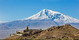 |
| Mount Ararat, as
seen from Khor Virap, Armenia. |
Mountains
A mountain is an elevated portion of the Earth's crust,
generally with steep sides that show significant exposed
bedrock. A mountain differs from a plateau in having a
limited summit area, and is larger than a hill,
typically rising at least 300 metres (1000 feet) above
the surrounding land. A few mountains are isolated
summits, but most occur in mountain ranges.
Mountains are formed through tectonic forces, erosion,
or volcanism, which act on time scales of up to tens of
millions of years. Once mountain building ceases,
mountains are slowly leveled through the action of
weathering, through slumping and other forms of mass
wasting, and through erosion by rivers and glaciers.
High elevations on mountains produce colder climates
than at sea level at similar latitude. These colder
climates strongly affect the ecosystems of mountains:
different elevations have different plants and animals.
Because of the less hospitable terrain and climate,
mountains tend to be used less for agriculture and more
for resource extraction, such as mining and logging, and
recreation, such as mountain climbing and skiing.
The highest mountain on Earth is Mount Everest in the
Himalayas of Asia, whose summit is 8,850 m (29,035 ft)
above mean sea level. The highest known mountain on any
planet in the Solar System is Olympus Mons on Mars at
21,171 m (69,459 ft).
Definition of a mountain |
- The highest point of a mountain is
called the peak. A mountain's summit is the highest area
an individual can reach. A mountain climber will not
reach the peak of the mountain but can reach the summit.
- Britannica Student Encyclopedia says
that the term "mountain' usually means a rise of over
2,000 feet (610 m)".
- Polytechnic Student Encyclopedia
says that the term "mountain' usually means a rise of
over 1,000 feet (610 m)".
- The standard height for a mountain
in England is 600 metres. In England, it is important to
have a legal height because people have the "Right to
Roam" in mountains, but they do not have the same right
to walk on someone-else's land.
|
|
 |
| Geological
cross-section of Fuji volcano. |
Geology
There are three main types of mountains: volcanic, fold,
and block. All three types are formed from plate
tectonics: when portions of the Earth's crust move,
crumple, and dive. Compressional forces, isostatic
uplift and intrusion of igneous matter forces surface
rock upward, creating a landform higher than the
surrounding features. The height of the feature makes it
either a hill or, if higher and steeper, a mountain.
Major mountains tend to occur in long linear arcs,
indicating tectonic plate boundaries and activity.
Volcanoes
Volcanoes are formed when a plate is pushed below
another plate, or at a mid-ocean ridge or hotspot. At a
depth of around 100 km, melting occurs in rock above the
slab (due to the addition of water), and forms magma
that reaches the surface. When the magma reaches the
surface, it often builds a volcanic mountain, such as a
shield volcano or a stratovolcano. Examples of volcanoes
include Mount Fuji in Japan and Mount Pinatubo in the
Philippines. The magma does not have to reach the
surface in order to create a mountain: magma that
solidifies below ground can still form dome mountains,
such as Navajo Mountain in the US. |
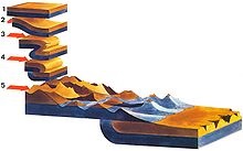 |
| Illustration of
mountains that developed on a fold that has been
thrusted. |
Fold mountains
Fold mountains occur when two plates collide: shortening
occurs along thrust faults and the crust is
overthickened. Since the less dense continental crust
"floats" on the denser mantle rocks beneath, the weight
of any crustal material forced upward to form hills,
plateaus or mountains must be balanced by the buoyancy
force of a much greater volume forced downward into the
mantle. Thus the continental crust is normally much
thicker under mountains, compared to lower lying areas.
Rock can fold either symmetrically or asymmetrically.
The upfolds are anticlines and the downfolds are
synclines: in asymmetric folding there may also be
recumbent and overturned folds. The Jura Mountains are
an example of fold mountains.
Block mountains
Block mountains are caused by faults in the crust: a
plane where rocks have moved past each other. When rocks
on one side of a fault rise relative to the other, it
can form a mountain. The uplifted blocks are block
mountains or horsts. The intervening dropped blocks are
termed graben: these can be small or form extensive rift
valley systems. This form of landscape can be seen in
East Africa, the Vosges, the Basin and Range Province of
Western North America and the Rhine valley. These areas
often occur when the regional stress is extensional and
the crust is thinned. |
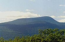 |
| The Catskills in
Upstate New York represent an eroded plateau. |
Erosion
During and following uplift, mountains are subjected to
the agents of erosion (water, wind, ice, and gravity)
which gradually wear the uplifted area down. Erosion
causes the surface of mountains to be younger than the
rocks that form the mountains themselves. Glacial
processes produce characteristic landforms, such as
pyramidal peaks, knife-edge arêtes, and bowl-shaped
cirques that can contain lakes. Plateau mountains, such
as the Catskills, are formed from the erosion of an
uplifted plateau.
In earth science, erosion is the action of surface
processes (such as water flow or wind) that removes
soil, rock, or dissolved material from one location on
the Earth's crust, and then transport it away to another
location (not to be confused with weathering which
involves no movement). The particulate breakdown of rock
or soil into clastic sediment is referred to as physical
or mechanical erosion; this contrasts with chemical
erosion, where soil or rock material is removed from an
area by its dissolving into a solvent (typically water),
followed by the flow away of that solution. Eroded
sediment or solutes may be transported just a few
millimeters, or for thousands of kilometers. |
|
 |
| A combination of
high latitude and high altitude makes the
northern Urals in picture to have climatic
conditions that make the ground barren. |
Climate
Climate in the mountains becomes colder at high
elevations, due to an interaction between radiation and
convection. Sunlight in the visible spectrum hits the
ground and heats it. The ground then heats the air at
the surface. If radiation were the only way to transfer
heat from the ground to space, the greenhouse effect of
gases in the atmosphere would keep the ground at roughly
333 K (60 °C; 140 °F), and the temperature would decay
exponentially with height.
However, when air is hot, it tends to expand, which
lowers its density. Thus, hot air tends to rise and
transfer heat upward. This is the process of convection.
Convection comes to equilibrium when a parcel of air at
a given altitude has the same density as its
surroundings. Air is a poor conductor of heat, so a
parcel of air will rise and fall without exchanging
heat. This is known as an adiabatic process, which has a
characteristic pressure-temperature dependence. As the
pressure gets lower, the temperature decreases. The rate
of decrease of temperature with elevation is known as
the adiabatic lapse rate, which is approximately 9.8 °C
per kilometer (or 5.4 °F per 1000 feet) of altitude.
Note that the presence of water in the atmosphere
complicates the process of convection. Water vapor
contains latent heat of vaporization. As air rises and
cools, it eventually becomes saturated and cannot hold
its quantity of water vapor. The water vapor condenses
(forming clouds), and releases heat, which changes the
lapse rate from the dry adiabatic lapse rate to the
moist adiabatic lapse rate (5.5 °C per kilometer or 3 °F
per 1000 feet) The actual lapse rate can vary by
altitude and by location.
Therefore, moving up 100 meters on a mountain is roughly
equivalent to moving 80 kilometers (45 miles or 0.75° of
latitude) towards the nearest pole. This relationship is
only approximate, however, since local factors such as
proximity to oceans (such as the Arctic Ocean) can
drastically modify the climate. As the altitude
increases, the main form of precipitation becomes snow
and the winds increase.
The effect of the climate on the ecology at an elevation
can be largely captured through a combination of amount
of precipitation, and the biotemperature, as described
by Leslie Holdridge in 1947. Biotemperature is the mean
temperature; all temperatures below 0 °C (32 °F) are
considered to be 0 °C. When the temperature is below 0
°C, plants are dormant, so the exact temperature is
unimportant. The peaks of mountains with permanent snow
can have a biotemperature below 1.5 °C (34.7 °F). |
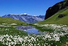 |
| An alpine mire in
the Swiss Alps. |
Ecology
The colder climate on mountains affects the plants and
animals residing on mountains. A particular set of
plants and animals tend to be adapted to a relatively
narrow range of climate. Thus, ecosystems tend to lie
along elevation bands of roughly constant climate. This
is called altitudinal zonation. In regions with dry
climates, the tendency of mountains to have higher
precipitation as well as lower temperatures also
provides for varying conditions, which enhances zonation.
Some plants and animals found in altitudinal zones tend
to become isolated since the conditions above and below
a particular zone will be inhospitable and thus
constrain their movements or dispersal. These isolated
ecological systems are known as sky islands.
Altitudinal zones tend to follow a typical pattern. At
the highest elevations, trees cannot grow, and whatever
life may be present will be of the alpine type,
resembling tundra. Just below the tree line, one may
find subalpine forests of needleleaf trees, which can
withstand cold, dry conditions. Below that, montane
forests grow. In the temperate portions of the earth,
those forests tend to be needleleaf trees, while in the
tropics, they can be broadleaf trees growing in a rain
forest. |
|
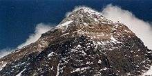 |
| Mount Everest, the
highest peak on Earth. |
Height
Tallest mountains
The highest mountain in the Solar System is the Olympus
Mons (27 km) on Mars. The highest mountain in the world
is Mount Everest (8,848m)which is in Nepal/Tibet in
Asia.
The "tallest" mountain in the world is Mauna Loa, in
Hawaii. The "height" of a mountain is measured from sea
level, but the "tallness" of a mountain is measured from
its base, even if under water. The highest mountain in
North America is Mount McKinley (6,194m) in Alaska in
the USA. The highest in South America is Aconcagua
(6,962m) in Argentina. For Africa, it is Kilimanjaro
(5,963m) of Tanzania. In Europe, the highest mountain is
in Russia called Elbrus (5,633m). Antarctica's highest
mountain is Vinsin Massiff (5,140m). In Oceania, a
mountain called Puncak Jaya (5,030m) is the highest
there. This particular mountain is in Papua New Guinea /
Indonesia. |
|
|
 Kiddle: Mountains Kiddle: Mountains
Wikipedia: Mountains |
|
|
|
|
|
|
|
|
|
|
|
|
|
|
|
|
|
|
Search Fun Easy English |
|
|
|
|
|
|
|
|
|
|
|
|
|
|
|
About
Contact
Copyright
Resources
Site Map |