|
|
| |
|
|
| |
|
|
|
|
| |
 |
| Cumuliform
cloudscape over Swifts Creek, Australia. |
Clouds
In meteorology, a cloud is an aerosol consisting of a
visible mass of minute liquid droplets, frozen crystals,
or other particles suspended in the atmosphere of a
planetary body or similar space. Water or various other
chemicals may compose the droplets and crystals. On
Earth, clouds are formed as a result of saturation of
the air when it is cooled to its dew point, or when it
gains sufficient moisture (usually in the form of water
vapor) from an adjacent source to raise the dew point to
the ambient temperature. They are seen in the Earth's
homosphere, which includes the troposphere,
stratosphere, and mesosphere. Nephology is the science
of clouds, which is undertaken in the cloud physics
branch of meteorology. There are two methods of naming
clouds in their respective layers of the homosphere,
Latin and common.
Genus types in the troposphere, the atmospheric layer
closest to Earth's surface, have Latin names due to the
universal adoption of Luke Howard's nomenclature that
was formally proposed in 1802. It became the basis of a
modern international system that divides clouds into
five physical forms which can be further divided or
classified into altitude levels to derive ten basic
genera. The main representative cloud types for each of
these forms are stratus, cirrus, stratocumulus, cumulus,
and cumulonimbus. Low-level clouds do not have any
altitude-related prefixes. However mid-level stratiform
and stratocumuliform types are given the prefix alto-
while high-level variants of these same two forms carry
the prefix cirro-. Genus types with sufficient vertical
extent to occupy more than one level do not carry any
altitude related prefixes. They are classified formally
as low- or mid-level depending on the altitude at which
each initially forms, and are also more informally
characterized as multi-level or vertical. Most of the
ten genera derived by this method of classification can
be subdivided into species and further subdivided into
varieties. Very low stratiform clouds that extend down
to the Earth's surface are given the common names fog
and mist, but have no Latin names. |
 |
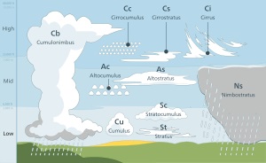
| Tropospheric cloud
classification by altitude of occurrence:
Multi-level and vertical genus-types not limited
to a single altitude level include nimbostratus,
cumulonimbus, and some of the larger cumulus
species. |
In the stratosphere and mesosphere, clouds
have common names for their main types. They may have
the appearance of stratiform veils or sheets, cirriform
wisps, or stratocumuliform bands or ripples. They are
seen infrequently, mostly in the polar regions of Earth.
Clouds have been observed in the atmospheres of other
planets and moons in the Solar System and beyond.
However, due to their different temperature
characteristics, they are often composed of other
substances such as methane, ammonia, and sulfuric acid,
as well as water.
Tropospheric clouds can have a direct effect on climate
change on Earth. They may reflect incoming rays from the
sun which can contribute to a cooling effect where and
when these clouds occur, or trap longer wave radiation
that reflects back up from the Earth's surface which can
cause a warming effect. The altitude, form, and
thickness of the clouds are the main factors that affect
the local heating or cooling of Earth and the
atmosphere. Clouds that form above the troposphere are
too scarce and too thin to have any influence on climate
change. Clouds are the main uncertainty in climate
sensitivity.
Warm air holds more water vapor than cool air. So if warm
air with lots of water inside cools, it can form a cloud.
These are ways air can cool enough to form clouds: |
- when air close to the ground is
heated by the sun and rises to where the air is colder.
- along weather fronts warmer air is
cooled as it runs into colder air;
- when air goes up the side of a
mountain it cools as it goes higher;
- when warm air goes over something
colder such as cool water in a lake) or ground that is
cooled at night it cools.
|
|
Cloud classification
Clouds are classified according to how they look and how
high the base of the cloud is in the sky. This system
was suggested in 1803. There are different sorts of
clouds because the air where they form can be still or
moving forward or up and down at different speeds. Very
thick clouds with large enough water droplets can make
rain or snow, and the biggest clouds can make thunder
and lightning.
There are five basic families of clouds based on how
they look: |
- Cirrus clouds are high and thin. The
air is very cold at high levels, so these clouds are
made of ice crystals instead of water droplets. Cirrus
clouds are sometimes called mares' tails because they
look like the tails of a horse.
- Stratus clouds are like flat sheets.
They may be low-level clouds (stratus), medium-level
(altostratus), high-level (cirrostratus), or thick
multi-level clouds that make rain or snow
(nimbostratus).
- Stratocumulus clouds are in the form
of rolls or ripples. They may be low-level clouds
(stratocumulus), medium-level (altocumulus), or
high-level (cirrocumulus).
- Cumulus clouds are puffly and small
when they first form. They may grow into heap clouds
that have moderate vertical extent (nothing added to the
name), or become towering vertical clouds (towering
cumulus).
- Cumulonimbus clouds are very large
cumulus-type clouds that usually develop cirrus tops and
sometimes other features that give them their own unique
look.
|
|
The following is a summary of the main cloud types arranged
by how high they form: |
|
High-Level clouds
High clouds form from 10,000 to 25,000 ft (3,000 to
8,000 m) in cold places, 16,500 to 40,000 ft (5,000 to
12,000 m) in mild regions and 20,000 to 60,000 ft (6,000
to 18,000 m) in the very hot tropics. They are too high
and thin to produce rain or snow.
High-level clouds include: |
- Cirrus (Ci)
- Cirrocumulus (Cc)
- Cirrostratus (Cs)
|
Medium-level clouds
Middle clouds usually form at 6,500 ft (2,000 m) in colder
areas. However, they may form as high as 25,000 ft (8,000 m)
in the tropics where it's very warm all year. Middle clouds
are usually made of water droplets but may also have some
ice crystals. They occasionally produce rain or snow that
usually evaporates before reaching the ground.
Medium-level clouds include: |
- Altocumulus (Ac)
- Altostratus (As)
|
Low-level clouds
Low-level clouds are usually seen from near ground level to
as high as 6,500 ft (2,000 m). Low clouds are usually made
of water droplets and may occasionally produce very light
rain, drizzle, or snow.
Low-level clouds include: |
- Stratocumulus (Sc)
- Stratus (St)
|
|
When very low stratus cloud touches the ground, it is called
fog. |
|
Moderate-vertical clouds
These are clouds of medium thickness that can form
anywhere from near ground level to as high as 10,000 ft
(3,000 m). Medium-level cumulus does not have alto added
to its name. The tops of these clouds are usually not
much higher than 20,000 ft (6,000 m). Vertical clouds
often create rain and snow. They are made mostly of
water droplets, but when they push up through cold
higher levels they may also have ice crystals.
Moderate-vertical clouds include: |
- Cumulus (Cu)
- Nimbostratus (Ns)
|
Towering-vertical clouds
These clouds are very tall with tops usually higher than
20,000 ft (6,000 m). They can create heavy rain and snow
showers. Cumulonimbus, the biggest clouds of all, can also
produce thunderstorms. These clouds are mostly made of water
droplets, but the tops of very large cumulonimbus clouds are
often made mostly of ice crystals.
Towering-vertical clouds include: |
- Towering cumulus (Tcu)
- Cumulonimbus (Cb)
|
 Kiddle: Clouds Kiddle: Clouds
Wikipedia: Clouds |
|
|
 |
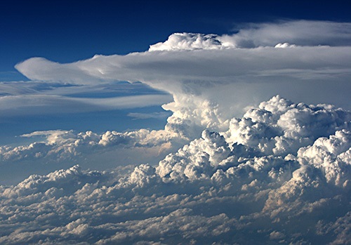
| Cumulonimbus cloud
seen from 38,000 feet. |
Introduction to
Clouds
We see clouds almost daily. But clouds are complicated and
varied. In fact, the presence of a generic cloud means
almost nothing without more details.
Clouds can grow very tall or appear flat as a pancake. They
are typically white in color but can also be different
shades of grey or brilliant yellow, orange or red. They can
weigh tens of millions of tons yet float in the atmosphere.
Clouds can be harbingers of good weather or bad. Their
absence can be a good thing after a flooding rain or a bad
thing during a drought.
They provide relief from the heat of direct sunlight but
also trap warmth, leading to higher temperatures.
Precipitation from clouds helps crops to grow, but can make
driving more dangerous due to reduced visibility.
They come in infinite shapes and sizes yet we often
recognize more familiar objects or animals.
Clouds can be carried along by winds of up to 150 mph (240
km/h) or can remain stationary while the wind passes through
them.
They can form behind high flying aircraft or can dissipate
as a plane flies through them. They are not confined to
earth but are found on other planets as well.
What are clouds? They are the visible aggregate of minute
particles of water and/or ice which form when water vapor
condenses. Learn about clouds and how they form to become "Cloudwise". |
 |
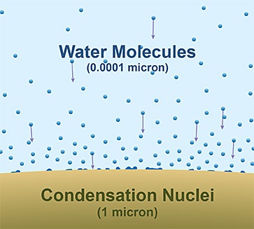
| The relative size of
water molecules to condensation nuclei. |
How Clouds Form
There are two ingredients needed for clouds to become
visible; water, of course, and nuclei.
Nuclei
In one form or another water is always present in the
atmosphere. However, water molecules in the atmosphere are
too small to bond together for the formation of cloud
droplets. They need a "flatter" surface, an object with a
radius of at least one micrometer (one millionth of a meter)
on which they can form a bond. Those objects are called
nuclei.
Nuclei are minute solid and liquid particles found in
abundance. They consist of such things as smoke particles
from fires or volcanoes, ocean spray or tiny specks of
wind-blown soil. These nuclei are hygroscopic meaning they
attract water molecules.
Called "cloud condensation nuclei", these
water-molecule-attracting particles are about 1/100th the
size of a cloud droplet upon which water condenses.
Therefore, every cloud droplet has a speck of dirt, dust or
salt crystal at its core. But, even with a condensation
nuclei, the cloud droplet is essentially made up of pure
water. |
 |
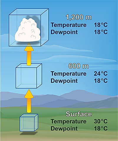
| In an ideal
atmosphere the saturation level of a parcel with
a surface temperature of 85°F and a dew point of
65°F will cool to the saturation point at about
4,000 feet in elevation. Click image to change
from English to metric unit. |
Temperature's
role
But having water attracting nuclei is not enough for a cloud
to form as the air temperature needs to be below the
saturation point. Called the dew point temperature, the
point of saturation is where evaporation equals
condensation.
Therefore, a cloud results when a block of air (called a
parcel) containing water vapor has cooled below the point of
saturation. Air can reach the point of saturation in a
number of ways. The most common way is through lifting of
air from the surface up into the atmosphere.
As a bubble of air, called a parcel, rises it moves into
lower pressure since pressure decreases with height. The
result is the parcel expands in size as it rises. This
requires heat energy to be removed from the parcel. Called
an adiabatic process, as air rises and expands it cools.
The rate at which the parcel cools with increasing elevation
is called the "lapse rate". The lapse rate (the rate the
temperature lapses or decreases) of unsaturated air (air
with relative humidity <100%) is 5.5°F per 1000 feet (9.8°C
per kilometer). Called the dry lapse rate, for each 1000
feet increase in elevation, the air temperature will
decrease 5.5°F.
Once the parcel reaches saturation temperature (100%
relative humidity) water vapor will condense onto the cloud
condensation nuclei resulting in the formation of a cloud
droplet.
But the atmosphere is in constant motion. As air rises drier
air is added (entrained) into the rising parcel so both
condensation and evaporation are continually occurring. So,
cloud droplets are constantly forming and dissipating.
Therefore, clouds form and grow when there is more
condensation on nuclei than evaporation from nuclei.
Conversely, they dissipate if there is more evaporation than
condensation. Thus, clouds appear and disappear as well as
constantly change shape. |
|
|
|
|
|
|
|
|
|
|
|
|
|
|
|
|
|
|
Search Fun Easy English |
|
|
|
|
|
|
|
|
|
|
|
|
|
|
|
About
Contact
Copyright
Resources
Site Map |