|
|
| |
|
|
| |
|
|
|
|
| |
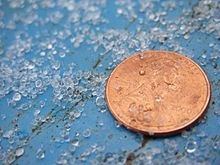 |
| Ice pellets next to
a U.S. penny for scale. |
Ice Pellets
Ice pellets are a form of precipitation consisting of
small, translucent balls of ice. Ice pellets are
different from graupel ("soft hail") which is made of
frosty white rime, and from a mixture of rain and snow
which is a slushy liquid or semisolid. Ice pellets often
bounce when they hit the ground or other solid objects,
and make a higher-pitched "tap" when striking objects
like jackets, windshields, and dried leaves, compared to
the dull splat of liquid raindrops. Pellets generally do
not freeze into a solid mass unless mixed with freezing
rain. The METAR code for ice pellets is PL (PE before
November 1998). |
|
Terminology
Ice pellets are known as sleet in the United States, the
official term used by the U.S. National Weather Service.
However, the term sleet refers to a mixture of rain and
snow in most Commonwealth countries, including Canada.
Because of this, Environment Canada never uses the term
sleet, and uses the terms "ice pellets" or "wet snow"
instead. |
|
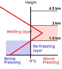 |
| Temperature profile
for ice pellet formation. |
Formation
Ice pellets form when a layer of above-freezing air is
located between 1,500 and 3,000 meters (5,000 and 10,000
ft) above the ground, with sub-freezing air both above
and below it. This causes the partial or complete
melting of any snowflakes falling through the warm layer
(the French term for sleet, neige fondue, literally
means "melted snow" because of this). As they fall back
into the sub-freezing layer closer to the surface, they
re-freeze into ice pellets. However, if the sub-freezing
layer beneath the warm layer is too small, the
precipitation will not have time to re-freeze before
hitting the surface, so it will become freezing rain. A
temperature profile showing a warm layer above the
ground is most likely to be found in advance of a warm
front during the cold season, but can occasionally be
found behind a passing cold front, and often with a
stationary front. |
|
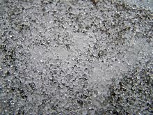 |
| An accumulation of
ice pellets. |
Effects
In most parts of the world, ice pellets only occur for
brief periods and do not accumulate a significant
amount. However, across the eastern United States and
southeastern Canada, warm air flowing north from the
Gulf of Mexico ahead of a strong synoptic-scale storm
system can overrun cold, dense air at the surface for
many hundreds of miles for an extended period of time.
In these areas, ice pellet accumulations of 2–5 cm
(0.8–2.0 in) are not unheard of. The effects of a
significant accumulation of ice pellets are not unlike
an accumulation of snow. One significant difference is
that for the same volume of snow, an equal volume of ice
pellets is significantly heavier and thus more difficult
to clear away. Additionally, a volume of ice pellets
takes significantly longer to melt compared to an equal
volume of fresh snowfall. |
|
|
 Wikipedia: Ice Pellets Wikipedia: Ice Pellets |
|
|
|
|
|
|
|
|
|
|
|
|
|
|
|
|
Search Fun Easy English |
|
|
|
|
|
|
|
|
|
|
|
|
|
|
|
About
Contact
Copyright
Resources
Site Map |
