|
|
| |
|
|
| |
|
|
|
|
| |
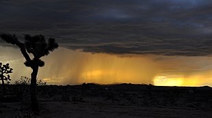 |
| Heavy rain falling
over the desert at sunset. |
Rain
Rain is liquid water in the form of droplets that have
condensed from atmospheric water vapor and then become
heavy enough to fall under gravity. Rain is a major
component of the water cycle and is responsible for
depositing most of the fresh water on the Earth. It
provides suitable conditions for many types of
ecosystems, as well as water for hydroelectric power
plants and crop irrigation.
The major cause of rain production is moisture moving
along three-dimensional zones of temperature and
moisture contrasts known as weather fronts. If enough
moisture and upward motion is present, precipitation
falls from convective clouds (those with strong upward
vertical motion) such as cumulonimbus (thunder clouds)
which can organize into narrow rainbands. In mountainous
areas, heavy precipitation is possible where upslope
flow is maximized within windward sides of the terrain
at elevation which forces moist air to condense and fall
out as rainfall along the sides of mountains. On the
leeward side of mountains, desert climates can exist due
to the dry air caused by downslope flow which causes
heating and drying of the air mass. The movement of the
monsoon trough, or intertropical convergence zone,
brings rainy seasons to savannah climes.
The urban heat island effect leads to increased
rainfall, both in amounts and intensity, downwind of
cities. Global warming is also causing changes in the
precipitation pattern globally, including wetter
conditions across eastern North America and drier
conditions in the tropics. Antarctica is the driest
continent. The globally averaged annual precipitation
over land is 715 mm (28.1 in), but over the whole Earth
it is much higher at 990 mm (39 in). Climate
classification systems such as the Köppen classification
system use average annual rainfall to help differentiate
between differing climate regimes. Rainfall is measured
using rain gauges. Rainfall amounts can be estimated by
weather radar.
Rain is also known or suspected on other planets, where
it may be composed of methane, neon, sulfuric acid, or
even iron rather than water. |
|
 |
| The shape of rain
drops depending upon their size. |
Formation
Water-saturated air
Air contains water vapor, and the amount of water in a
given mass of dry air, known as the mixing ratio, is
measured in grams of water per kilogram of dry air
(g/kg). The amount of moisture in air is also commonly
reported as relative humidity; which is the percentage
of the total water vapor air can hold at a particular
air temperature. How much water vapor a parcel of air
can contain before it becomes saturated (100% relative
humidity) and forms into a cloud (a group of visible and
tiny water and ice particles suspended above the Earth's
surface) depends on its temperature. Warmer air can
contain more water vapor than cooler air before becoming
saturated. Therefore, one way to saturate a parcel of
air is to cool it. The dew point is the temperature to
which a parcel must be cooled in order to become
saturated.
There are four main mechanisms for cooling the air to
its dew point: adiabatic cooling, conductive cooling,
radiational cooling, and evaporative cooling. Adiabatic
cooling occurs when air rises and expands. The air can
rise due to convection, large-scale atmospheric motions,
or a physical barrier such as a mountain (orographic
lift). Conductive cooling occurs when the air comes into
contact with a colder surface, usually by being blown
from one surface to another, for example from a liquid
water surface to colder land. Radiational cooling occurs
due to the emission of infrared radiation, either by the
air or by the surface underneath. Evaporative cooling
occurs when moisture is added to the air through
evaporation, which forces the air temperature to cool to
its wet-bulb temperature, or until it reaches
saturation.
The main ways water vapor is added to the air are: wind
convergence into areas of upward motion, precipitation
or virga falling from above, daytime heating evaporating
water from the surface of oceans, water bodies or wet
land, transpiration from plants, cool or dry air moving
over warmer water, and lifting air over mountains. Water
vapor normally begins to condense on condensation nuclei
such as dust, ice, and salt in order to form clouds.
Elevated portions of weather fronts (which are
three-dimensional in nature) force broad areas of upward
motion within the Earth's atmosphere which form clouds
decks such as altostratus or cirrostratus. Stratus is a
stable cloud deck which tends to form when a cool,
stable air mass is trapped underneath a warm air mass.
It can also form due to the lifting of advection fog
during breezy conditions. |
|
Causes
Frontal activity
Stratiform (a broad shield of precipitation with a
relatively similar intensity) and dynamic precipitation
(convective precipitation which is showery in nature
with large changes in intensity over short distances)
occur as a consequence of slow ascent of air in synoptic
systems (on the order of cm/s), such as in the vicinity
of cold fronts and near and poleward of surface warm
fronts. Similar ascent is seen around tropical cyclones
outside the eyewall, and in comma-head precipitation
patterns around mid-latitude cyclones. A wide variety of
weather can be found along an occluded front, with
thunderstorms possible, but usually their passage is
associated with a drying of the air mass. Occluded
fronts usually form around mature low-pressure areas.
What separates rainfall from other precipitation types,
such as ice pellets and snow, is the presence of a thick
layer of air aloft which is above the melting point of
water, which melts the frozen precipitation well before
it reaches the ground. If there is a shallow near
surface layer that is below freezing, freezing rain
(rain which freezes on contact with surfaces in
subfreezing environments) will result. Hail becomes an
increasingly infrequent occurrence when the freezing
level within the atmosphere exceeds 3,400 m (11,000 ft)
above ground level. |
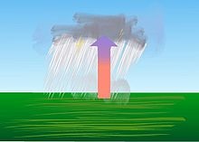 |
| Convective
precipitation. |
Convection
Convective rain, or showery precipitation, occurs from
convective clouds (e.g., cumulonimbus or cumulus
congestus). It falls as showers with rapidly changing
intensity. Convective precipitation falls over a certain
area for a relatively short time, as convective clouds
have limited horizontal extent. Most precipitation in
the tropics appears to be convective; however, it has
been suggested that stratiform precipitation also
occurs. Graupel and hail indicate convection. In
mid-latitudes, convective precipitation is intermittent
and often associated with baroclinic boundaries such as
cold fronts, squall lines, and warm fronts. |
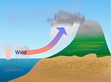 |
| Orographic
precipitation. |
Orographic
effects
Orographic precipitation occurs on the windward side of
mountains and is caused by the rising air motion of a
large-scale flow of moist air across the mountain ridge,
resulting in adiabatic cooling and condensation. In
mountainous parts of the world subjected to relatively
consistent winds (for example, the trade winds), a more
moist climate usually prevails on the windward side of a
mountain than on the leeward or downwind side. Moisture
is removed by orographic lift, leaving drier air (see
katabatic wind) on the descending and generally warming,
leeward side where a rain shadow is observed.
In Hawaii, Mount Waiʻaleʻale, on the island of Kauai, is
notable for its extreme rainfall, as it is amongst the
places in the world with the highest levels of rainfall,
with 9,500 mm (373 in). Systems known as Kona storms
affect the state with heavy rains between October and
April. Local climates vary considerably on each island
due to their topography, divisible into windward (Koʻolau)
and leeward (Kona) regions based upon location relative
to the higher mountains. Windward sides face the east to
northeast trade winds and receive much more rainfall;
leeward sides are drier and sunnier, with less rain and
less cloud cover.
In South America, the Andes mountain range blocks
Pacific moisture that arrives in that continent,
resulting in a desertlike climate just downwind across
western Argentina. The Sierra Nevada range creates the
same effect in North America forming the Great Basin and
Mojave Deserts. |
 |
| Rainfall
distribution by month in Cairns showing the
extent of the wet season at that location. |
Within the
tropics
The wet, or rainy, season is the time of year, covering
one or more months, when most of the average annual
rainfall in a region falls. The term green season is
also sometimes used as a euphemism by tourist
authorities. Areas with wet seasons are dispersed across
portions of the tropics and subtropics. Savanna climates
and areas with monsoon regimes have wet summers and dry
winters. Tropical rainforests technically do not have
dry or wet seasons, since their rainfall is equally
distributed through the year. Some areas with pronounced
rainy seasons will see a break in rainfall mid-season
when the intertropical convergence zone or monsoon
trough move poleward of their location during the middle
of the warm season. When the wet season occurs during
the warm season, or summer, rain falls mainly during the
late afternoon and early evening hours. The wet season
is a time when air quality improves, freshwater quality
improves, and vegetation grows significantly.
Tropical cyclones, a source of very heavy rainfall,
consist of large air masses several hundred miles across
with low pressure at the centre and with winds blowing
inward towards the centre in either a clockwise
direction (southern hemisphere) or counter clockwise
(northern hemisphere). Although cyclones can take an
enormous toll in lives and personal property, they may
be important factors in the precipitation regimes of
places they impact, as they may bring much-needed
precipitation to otherwise dry regions. Areas in their
path can receive a year's worth of rainfall from a
tropical cyclone passage. |
 |
| Standard rain gauge. |
Measurement
Rain is measured in units of length per unit time,
typically in millimeters per hour, or in countries where
imperial units are more common, inches per hour. The
"length", or more accurately, "depth" being measured is
the depth of rain water that would accumulate on a flat,
horizontal and impermeable surface during a given amount
of time, typically an hour. One millimeter of rainfall
is the equivalent of one liter of water per square
meter.
The standard way of measuring rainfall or snowfall is
the standard rain gauge, which can be found in 100-mm
(4-in) plastic and 200-mm (8-in) metal varieties. The
inner cylinder is filled by 25 mm (0.98 in) of rain,
with overflow flowing into the outer cylinder. Plastic
gauges have markings on the inner cylinder down to 0.25
mm (0.0098 in) resolution, while metal gauges require
use of a stick designed with the appropriate 0.25 mm
(0.0098 in) markings. After the inner cylinder is
filled, the amount inside it is discarded, then filled
with the remaining rainfall in the outer cylinder until
all the fluid in the outer cylinder is gone, adding to
the overall total until the outer cylinder is empty.
Other types of gauges include the popular wedge gauge
(the cheapest rain gauge and most fragile), the tipping
bucket rain gauge, and the weighing rain gauge. For
those looking to measure rainfall the most
inexpensively, a can that is cylindrical with straight
sides will act as a rain gauge if left out in the open,
but its accuracy will depend on what ruler is used to
measure the rain with. Any of the above rain gauges can
be made at home, with enough know-how.
When a precipitation measurement is made, various
networks exist across the United States and elsewhere
where rainfall measurements can be submitted through the
Internet, such as CoCoRAHS or GLOBE. If a network is not
available in the area where one lives, the nearest local
weather or met office will likely be interested in the
measurement. |
|
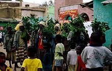 |
| Photograph of a rain
dance being performed in Harar, Ethiopia. |
Impact
Agricultural
Precipitation, especially rain, has a dramatic effect on
agriculture. All plants need at least some water to
survive, therefore rain (being the most effective means
of watering) is important to agriculture. While a
regular rain pattern is usually vital to healthy plants,
too much or too little rainfall can be harmful, even
devastating to crops. Drought can kill crops and
increase erosion, while overly wet weather can cause
harmful fungus growth. Plants need varying amounts of
rainfall to survive. For example, certain cacti require
small amounts of water, while tropical plants may need
up to hundreds of inches of rain per year to survive.
In areas with wet and dry seasons, soil nutrients
diminish and erosion increases during the wet season.
Animals have adaptation and survival strategies for the
wetter regime. The previous dry season leads to food
shortages into the wet season, as the crops have yet to
mature. Developing countries have noted that their
populations show seasonal weight fluctuations due to
food shortages seen before the first harvest, which
occurs late in the wet season. Rain may be harvested
through the use of rainwater tanks; treated to potable
use or for non-potable use indoors or for irrigation.
Excessive rain during short periods of time can cause
flash floods.
Cultural and religious
Cultural attitudes towards rain differ across the world.
In temperate climates, people tend to be more stressed
when the weather is unstable or cloudy, with its impact
greater on men than women. Rain can also bring joy, as
some consider it to be soothing or enjoy the aesthetic
appeal of it. In dry places, such as India, or during
periods of drought, rain lifts people's moods. In
Botswana, the Setswana word for rain, pula, is used as
the name of the national currency, in recognition of the
economic importance of rain in its country, since it has
a desert climate. Several cultures have developed means
of dealing with rain and have developed numerous
protection devices such as umbrellas and raincoats, and
diversion devices such as gutters and storm drains that
lead rains to sewers. Many people find the scent during
and immediately after rain pleasant or distinctive. The
source of this scent is petrichor, an oil produced by
plants, then absorbed by rocks and soil, and later
released into the air during rainfall.
Rain holds an important religious significance in many
cultures. The ancient Sumerians believed that rain was
the semen of the sky-god An, which fell from the heavens
to inseminate his consort, the earth-goddess Ki, causing
her to give birth to all the plants of the earth. The
Akkadians believed that the clouds were the breasts of
Anu's consort Antu and that rain was milk from her
breasts. According to Jewish tradition, in the first
century BC, the Jewish miracle-worker Honi ha-M'agel
ended a three-year drought in Judaea by drawing a circle
in the sand and praying for rain, refusing to leave the
circle until his prayer was granted. In his Meditations,
the Roman emperor Marcus Aurelius preserves a prayer for
rain made by the Athenians to the Greek sky-god Zeus.
Various Native American tribes are known to have
historically conducted rain dances in effort to
encourage rainfall. Rainmaking rituals are also
important in many African cultures. In the present-day
United States, various state governors have held Days of
Prayer for rain, including the Days of Prayer for Rain
in the State of Texas in 2011. |
|
|
 Kiddle: Rain Kiddle: Rain
Wikipedia: Rain |
|
|
|
|
|
|
|
|
|
|
|
|
|
|
|
|
Search Fun Easy English |
|
|
|
|
|
|
|
|
|
|
|
|
|
|
|
About
Contact
Copyright
Resources
Site Map |
