|
|
| |
|
|
| |
|
|
|
|
| |
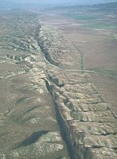 |
| The San Andreas
Fault in California. |
Geology
Geology (from the Ancient Greek γῆ, gē ("earth") and
-λoγία, -logia, ("study of", "discourse")) is an Earth
science concerned with the solid Earth, the rocks of
which it is composed, and the processes by which they
change over time. Geology can also include the study of
the solid features of any terrestrial planet or natural
satellite such as Mars or the Moon. Modern geology
significantly overlaps all other Earth sciences,
including hydrology and the atmospheric sciences, and so
is treated as one major aspect of integrated Earth
system science and planetary science.
Geology describes the structure of the Earth on and
beneath its surface, and the processes that have shaped
that structure. It also provides tools to determine the
relative and absolute ages of rocks found in a given
location, and also to describe the histories of those
rocks.[3] By combining these tools, geologists are able
to chronicle the geological history of the Earth as a
whole, and also to demonstrate the age of the Earth.
Geology provides the primary evidence for plate
tectonics, the evolutionary history of life, and the
Earth's past climates.
Geologists use a wide variety of methods to understand
the Earth's structure and evolution, including field
work, rock description, geophysical techniques, chemical
analysis, physical experiments, and numerical modelling.
In practical terms, geology is important for mineral and
hydrocarbon exploration and exploitation, evaluating
water resources, understanding of natural hazards, the
remediation of environmental problems, and providing
insights into past climate change. Geology is a major
academic discipline, and it plays an important role in
geotechnical engineering. |
|
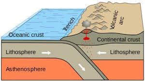 |
| Oceanic-continental
convergence resulting in subduction and volcanic
arcs illustrates one effect of plate tectonics. |
Plate tectonics
In the 1960s, it was discovered that the Earth's
lithosphere, which includes the crust and rigid
uppermost portion of the upper mantle, is separated into
tectonic plates that move across the plastically
deforming, solid, upper mantle, which is called the
asthenosphere. This theory is supported by several types
of observations, including seafloor spreading and the
global distribution of mountain terrain and seismicity.
There is an intimate coupling between the movement of
the plates on the surface and the convection of the
mantle (that is, the heat transfer caused by the bulk
movement of molecules within fluids). Thus, oceanic
plates and the adjoining mantle convection currents
always move in the same direction – because the oceanic
lithosphere is actually the rigid upper thermal boundary
layer of the convecting mantle. This coupling between
rigid plates moving on the surface of the Earth and the
convecting mantle is called plate tectonics.
In this diagram based on seismic tomography, subducting
slabs are in blue and continental margins and a few
plate boundaries are in red. The blue blob in the
cutaway section is the Farallon Plate, which is
subducting beneath North America. The remnants of this
plate on the surface of the Earth are the Juan de Fuca
Plate and Explorer Plate, both in the northwestern
United States and southwestern Canada and the Cocos
Plate on the west coast of Mexico.
The development of plate tectonics has provided a
physical basis for many observations of the solid Earth.
Long linear regions of geologic features are explained
as plate boundaries. |
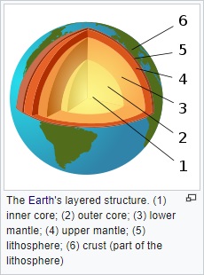
Earth structure
Advances in seismology, computer modeling, and
mineralogy and crystallography at high temperatures and
pressures give insights into the internal composition
and structure of the Earth.
Seismologists can use the arrival times of seismic waves
in reverse to image the interior of the Earth. Early
advances in this field showed the existence of a liquid
outer core (where shear waves were not able to
propagate) and a dense solid inner core. These advances
led to the development of a layered model of the Earth,
with a crust and lithosphere on top, the mantle below
(separated within itself by seismic discontinuities at
410 and 660 kilometers), and the outer core and inner
core below that. More recently, seismologists have been
able to create detailed images of wave speeds inside the
earth in the same way a doctor images a body in a CT
scan. These images have led to a much more detailed view
of the interior of the Earth, and have replaced the
simplified layered model with a much more dynamic model.
Mineralogists have been able to use the pressure and
temperature data from the seismic and modeling studies
alongside knowledge of the elemental composition of the
Earth to reproduce these conditions in experimental
settings and measure changes in crystal structure. These
studies explain the chemical changes associated with the
major seismic discontinuities in the mantle and show the
crystallographic structures expected in the inner core
of the Earth.
Geology subjects
Geology is divided into special subjects that study one
part of geology. Some of these subjects are: |
- Geomorphology – the study of the
shape (morphology) of the surface of the Earth.
- Historical geology – the history of
the events that shaped the Earth over the last 4.5
million years.
- Hydrogeology – the study of water
under the surface of the Earth
- Palaeontology – the study of fossils
- Petrology – the study of rocks how
they form and where they are from.
- Mineralogy – the study of minerals
- Sedimentology – the study of
sediments
- Stratigraphy – the study of layered
sedimentary rocks and how they were deposited.
- Structural geology– the study of
folds and faults and how mountains are formed by uplift.
- Volcanology – the study of volcanoes
on land or under the ocean
- Seismology – the study of
earthquakes and strong ground-motion.
- Engineering geology -the study of
geologic hazards (such as landslides and earthquakes)
applied to civil engineering.
- Petroleum geology- the study of
petroleum deposits in sedimentary rocks.
|
|
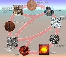 |
| The rock cycle shows
the relationship between igneous, sedimentary,
and metamorphic rocks. |
Types of rock
Rocks can be found in all sorts of shapes and colours.
Some are very hard and some are soft. Some rocks are
very common, while others are rare. However, all the
different rocks belong to three categories or types,
igneous, sedimentary and metamorphic.
Igneous rock
Igneous rock is rock that has been made by volcanic
action. Igneous rock is made when the lava (melted rock
on the surface of the Earth) or magma (melted rock below
the surface of the Earth) cools down and becomes hard.
Sedimentary rock
Sedimentary rock is rock that has been made from
sediment. Sediment is all solid pieces of stuff that are
moved by the wind, water, or glaciers. Sediment can be
made from clay, sand, gravel and the bodies and shells
of animals. The sediment gets dropped in a layer at the
bottom of a river or sea. As the sediment piles up, the
lowers layers get squashed together. Slowly they set
hard into rock. Some sedimentary rocks are made of just
one type of sediment, all about the same size, such as
sand. Other sedimentary rocks will have large and small
lumps, and pieces made of different types of rock.
Well-known sedimentary rocks are sandstone and
limestone.
Metamorphic rock
Metamorphic rock is rock that has been changed. The word
"metamorphosis" means "change". Sometimes an igneous, or
a sedimentary rock can be heated, or squashed under the
ground, so that it changes. Metamorphic rock is often
harder than the rock that it was before it changed. One
well-known metamorphic rock is marble which is valued
for its different colours, and because it can be carved
and polished. Slate is a metamorphic rock that is a
useful building material.
Faults
All three kinds of rock can be changed by being heated
and squeezed by forces in the earth. When this happens,
faults (cracks) may appear in the rock. Geologists can
learn a lot about the history of the rock by studying
the patterns of the fault lines. Earthquakes are caused
when a fault breaks suddenly.
Soil
Soil is the stuff on the ground made of lots of
particles (or tiny pieces). The particles of soil come
from rocks that have broken down, and from rotting
leaves and animals bodies. Soil covers a lot of the
surface of the Earth. Plants of all sorts grow in soil. |
|
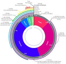
Geologic time
The geologic time scale encompasses the history of the
Earth. It is bracketed at the earliest by the dates of
the first Solar System material at 4.567 Ga (or 4.567
billion years ago) and the formation of the Earth at
4.54 Ga (4.54 billion years), which is the beginning of
the informally recognized Hadean eon – a division of
geologic time. At the later end of the scale, it is
marked by the present day (in the Holocene epoch).
Principles of Stratigraphy
Geologists use some simple ideas which help them to
understand the rocks they are studying. The following
ideas were worked out in the early days of stratigraphy
by people like Nicolaus Steno, James Hutton and William
Smith: |
- Understanding the past:
Geologist James Hutton said "The present is the key
to the past". He meant that the sort of changes that
are happening to the Earth's surface now are the
same sorts of things that happened in the past.
Geologists can understand things that happened
millions of years ago, by looking at the changes
which are happening today.
- Horizontal strata: The layers in
a sedimentary rock must have been horizontal (flat)
when they were deposited (laid down).
- The age of the strata: Layers at
the bottom must be older than layers at the top,
unless all the rocks have been turned over.
- In sedimentary rocks that are
made of sand or gravel, the sand or gravel must have
come from an older rock.
- The age of faults: If there is a
crack or fault in a rock, then the fault is younger
than the rock. Rocks are in strata (lots of layers).
A geologist can see if the faults go through all the
layer, or only some. This helps to tell the age of
the rocks.
- The age of a rock which cuts
through other rocks: If an igneous rock cuts across
sedimentary layers, it must be younger than the
sedimentary rock.
- The relative age of fossils: A
fossil in one rock type must be about the same age
as the same type of fossil in the same type of rock
in a different place. Likewise, a fossil in a rock
layer below must be earlier than one in a higher
layer.
|
|
|
|
|
|
|
|
|
|
|
|
|
|
|
|
|
|
|
Search Fun Easy English |
|
|
|
|
|
|
|
|
|
|
|
|
|
|
|
About
Contact
Copyright
Resources
Site Map |