|
|
| |
|
|
| |
|
|
|
|
| |
The Four Core Types of
Clouds
While clouds appear in infinite shapes and sizes they
fall into some basic forms. From his Essay of the
Modifications of Clouds (1803) Luke Howard divided
clouds into three categories; cirrus, cumulus and
stratus. |
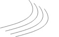
Cirro-form
The Latin word 'cirro' means curl of hair. Composed of ice
crystals, cirro-form clouds are whitish and hair-like. There
are the high, wispy clouds to first appear in advance of a
low-pressure area such as a mid-latitude storm system or a
tropical system such as a hurricane. |
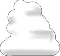
Cumulo-form
Generally detached clouds, they look like white fluffy
cotton balls. They show vertical motion or thermal uplift of
air taking place in the atmosphere. They are usually dense
in appearance with sharp outlines. The base of cumulus
clouds are generally flat and occurs at the altitude where
the moisture in rising air condenses. |
Strato-form
From the Latin word for 'layer' these clouds are usually
broad and fairly wide spread appearing like a blanket. They
result from non-convective rising air and tend to occur
along and to the north of warm fronts. The edges of strato-form
clouds are diffuse. |
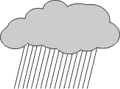
Nimbo-form
Howard also designated a special rainy cloud category which
combined the three forms Cumulo + Cirro + Stratus. He called
this cloud, 'Nimbus', the Latin word for rain. The vast
majority of precipitation occurs from nimbo-form clouds and
therefore these clouds have the greatest vertical height. |
|
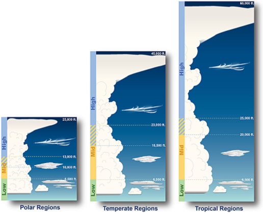
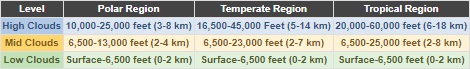
The Height of
Clouds
The traditional division between the Polar and Temperate
Regions is the Arctic Circle (66.5°N) in the Northern
Hemisphere and the Antarctic Circle (66.5°S) in the
Southern Hemisphere. The division between the Temperate
and Tropical Regions are the Tropics of Cancer (23.5°N)
in the Northern Hemisphere and the Tropics of Capricorn
(23.5°S) in the Southern Hemisphere.
The actual division between these regions varies from
day to day and season to season. Between the Polar and
Temperate Regions lies the jet stream in both
hemispheres, while the Sub-Tropical Jet Stream divides
the Temperate and Tropical Regions.
One effect of these cores of strong wind is the maximum
altitude of the tropopause decreases in each region as
one moves from the equator to the poles. Generally, as
the tropopause's height decreases, the elevations at
which clouds occur also decreases. |
|
The exception is for low clouds which are
officially said to have cloud bases within the first
6,500 feet (2,000 meters) of the surface in each region.
But even that is not always the case.
The base of cumulus and cumulonimbus clouds can
sometimes be higher than 6,500 feet (2,000 meters).
During summertime, the base of these convective clouds
will be well in to the mid-level cloud range in the
non-mountainous areas of the southwest United States. |
|
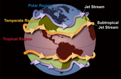 |
| The division between
these regions varies from day to day and season
to season based upon locations of the jet and
sub-tropical jet streams. |
Cumulus cloud bases have been observed up to
9,000 feet (2,750 meters) over North Central Texas and
thunderstorms, with cloud bases from 11,000 to 12,000
feet (3,350 to 3,650 meters), have occurred near San
Angelo, Texas.
This happens when, despite the dry lower level of the
atmosphere, the atmosphere in the mid-levels is fairly
moist and unstable. The dryness of the lower level is
such that parcels of air need to rise up to two miles (3
km), and sometimes more, before the they cool to the
point of condensation.
Since the jet stream follows the sun, it shifts toward
the equator as winter progresses. Therefore, the polar
region expands and the temperate region moves toward the
equator. In summer, the Tropical Region expands shifting
the temperate region toward the poles while the polar
region shrinks. |
|
|
|
|
|
|
|
|
|
|
|
|
|
|
|
|
|
|
Search Fun Easy English |
|
|
|
|
|
|
|
|
|
|
|
|
|
|
|
About
Contact
Copyright
Resources
Site Map |