|
|
| |
|
|
| |
|
|
|
|
| |
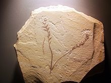 |
| Facsimile of a
fossil of Archaefructus from the Yixian
Formation, China. |
Cretaceous
The Cretaceous ( /krɪˈteɪ.ʃəs/, krih-TAY-shəs) is a
geological period that lasted from about 145 to 66
million years ago (mya). It is the third and final
period of the Mesozoic Era, as well as the longest. At
nearly 80 million years, it is the longest geological
period of the entire Phanerozoic. The name is derived
from the Latin creta, 'chalk', which is abundant in the
latter half of the period. It is usually abbreviated K,
for its German translation Kreide.
The Cretaceous was a period with a relatively warm
climate, resulting in high eustatic sea levels that
created numerous shallow inland seas. These oceans and
seas were populated with now-extinct marine reptiles,
ammonites and rudists, while dinosaurs continued to
dominate on land. The world was ice free, and forests
extended to the poles. During this time, new groups of
mammals and birds appeared. During the Early Cretaceous,
flowering plants appeared and began to rapidly
diversify, becoming the dominant group of plants across
the Earth by the end of the Cretaceous, coincident with
the decline and extinction of previously widespread
gymnosperm groups.
The Cretaceous (along with the Mesozoic) ended with the
Cretaceous–Paleogene extinction event, a large mass
extinction in which many groups, including non-avian
dinosaurs, pterosaurs, and large marine reptiles died
out. The end of the Cretaceous is defined by the abrupt
Cretaceous–Paleogene boundary (K–Pg boundary), a
geologic signature associated with the mass extinction
which lies between the Mesozoic and Cenozoic eras.
Etymology and history
The Cretaceous as a separate period was first defined by
Belgian geologist Jean d'Omalius d'Halloy in 1822 as the
"Terrain Crétacé", using strata in the Paris Basin and
named for the extensive beds of chalk (calcium carbonate
deposited by the shells of marine invertebrates,
principally coccoliths), found in the upper Cretaceous
of Western Europe. The name Cretaceous was derived from
Latin creta, meaning chalk. The twofold division of the
Cretaceous was implemented by Conybeare and Phillips in
1822. Alcide d'Orbigny in 1840 divided the French
Cretaceous into 5 “étages” (stages): the Neocomian,
Aptian, Albian, Turonian and Senonian, later adding the
"Urgonian" between Neocomian and Aptian and the
Cenomanian between the Albian and Turonian. |
|
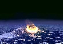 |
| The impact of a
meteorite or comet is today widely accepted as
the main reason for the Cretaceous–Paleogene
extinction event. |
Geology
Boundaries
The impact of a meteorite or comet is today widely
accepted as the main reason for the Cretaceous–Paleogene
extinction event.
There is not yet a globally-defined lower stratigraphic
boundary representing the start of the period. However,
the top of the system is sharply defined, being placed
at an iridium-rich layer found worldwide that is
believed to be associated with the Chicxulub impact
crater, with its boundaries circumscribing parts of the
Yucatán Peninsula and into the Gulf of Mexico. This
layer has been dated at 66.043 Ma.
A 140 Ma age for the Jurassic-Cretaceous boundary
instead of the usually accepted 145 Ma was proposed in
2014 based on a stratigraphic study of Vaca Muerta
Formation in Neuquén Basin, Argentina. Víctor Ramos, one
of the authors of the study proposing the 140 Ma
boundary age, sees the study as a "first step" toward
formally changing the age in the International Union of
Geological Sciences.
At the end of the Cretaceous, the impact of a large body
with the Earth may have been the punctuation mark at the
end of a progressive decline in biodiversity during the
Maastrichtian Age. The result was the extinction of
three-quarters of Earth's plant and animal species. The
impact created the sharp break known as K–Pg boundary
(formerly known as the K–T boundary). Earth's
biodiversity required substantial time to recover from
this event, despite the probable existence of an
abundance of vacant ecological niches. |
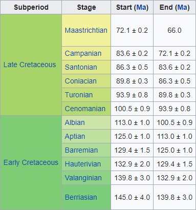 |
| Subperiods and
stages of the Cretaceous. |
Stratigraphy
The Cretaceous is divided into Early and Late Cretaceous
epochs, or Lower and Upper Cretaceous series. In older
literature the Cretaceous is sometimes divided into
three series: Neocomian (lower/early), Gallic (middle)
and Senonian (upper/late). A subdivision in twelve
stages, all originating from European stratigraphy, is
now used worldwide. In many parts of the world,
alternative local subdivisions are still in use.
From youngest to oldest, the subdivisions of the
Cretaceous period areas shown in the graphic.
Geologic formations
The high sea level and warm climate of the Cretaceous
meant large areas of the continents were covered by
warm, shallow seas, providing habitat for many marine
organisms. The Cretaceous was named for the extensive
chalk deposits of this age in Europe, but in many parts
of the world, the deposits from the Cretaceous are of
marine limestone, a rock type that is formed under warm,
shallow marine conditions. Due to the high sea level,
there was extensive space for such sedimentation.
Because of the relatively young age and great thickness
of the system, Cretaceous rocks are evident in many
areas worldwide.
Chalk is a rock type characteristic for (but not
restricted to) the Cretaceous. It consists of coccoliths,
microscopically small calcite skeletons of
coccolithophores, a type of algae that prospered in the
Cretaceous seas.
Stagnation of deep sea currents in middle Cretaceous
times caused anoxic conditions in the sea water leaving
the deposited organic matter undecomposed. Half of the
world's petroleum reserves were laid down at this time
in the anoxic conditions of what would become the
Persian Gulf and the Gulf of Mexico. In many places
around the world, dark anoxic shales were formed during
this interval, such as the Mancos Shale of western North
America. These shales are an important source rock for
oil and gas, for example in the subsurface of the North
Sea. |
|
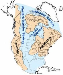 |
| Map of North America
during the mid-Cretaceous (95 mya), showing
Laramidia (left), Appalachia (right), the
Western Interior Seaway (center and upper left),
and other nearby seaways. |
Paleogeography
During the Cretaceous, the
late-Paleozoic-to-early-Mesozoic supercontinent of
Pangaea completed its tectonic breakup into the
present-day continents, although their positions were
substantially different at the time. As the Atlantic
Ocean widened, the convergent-margin mountain building (orogenies)
that had begun during the Jurassic continued in the
North American Cordillera, as the Nevadan orogeny was
followed by the Sevier and Laramide orogenies.
Gondwana had begun to break up during the Jurassic
period, but its fragmentation accelerated during the
Cretaceous and was largely complete by the end of the
period. South America, Antarctica and Australia rifted
away from Africa (though India and Madagascar remained
attached to each other until around 80 million years
ago); thus, the South Atlantic and Indian Oceans were
newly formed. Such active rifting lifted great undersea
mountain chains along the welts, raising eustatic sea
levels worldwide. To the north of Africa the Tethys Sea
continued to narrow. During the most of the Late
Cretaceous, North America would be divided in two by the
Western Interior Seaway, a large interior sea,
separating Laramidia to the west and Appalachia to the
east, then receded late in the period, leaving thick
marine deposits sandwiched between coal beds. At the
peak of the Cretaceous transgression, one-third of
Earth's present land area was submerged.
The Cretaceous is justly famous for its chalk; indeed,
more chalk formed in the Cretaceous than in any other
period in the Phanerozoic. Mid-ocean ridge activity—or
rather, the circulation of seawater through the enlarged
ridges—enriched the oceans in calcium; this made the
oceans more saturated, as well as increased the
bioavailability of the element for calcareous
nanoplankton. These widespread carbonates and other
sedimentary deposits make the Cretaceous rock record
especially fine. Famous formations from North America
include the rich marine fossils of Kansas's Smoky Hill
Chalk Member and the terrestrial fauna of the late
Cretaceous Hell Creek Formation. Other important
Cretaceous exposures occur in Europe (e.g., the Weald)
and China (the Yixian Formation). In the area that is
now India, massive lava beds called the Deccan Traps
were erupted in the very late Cretaceous and early
Paleocene. |
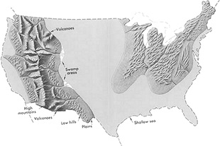 |
| Geography of the
Contiguous United States in the Late Cretaceous
period. |
Climate
The cooling trend of the last epoch of the Jurassic
continued into the first age of the Cretaceous. There is
evidence that snowfalls were common in the higher
latitudes, and the tropics became wetter than during the
Triassic and Jurassic. Glaciation was however restricted
to high-latitude mountains, though seasonal snow may
have existed farther from the poles. Rafting by ice of
stones into marine environments occurred during much of
the Cretaceous, but evidence of deposition directly from
glaciers is limited to the Early Cretaceous of the
Eromanga Basin in southern Australia.
After the end of the first age, however, temperatures
increased again, and these conditions were almost
constant until the end of the period. The warming may
have been due to intense volcanic activity which
produced large quantities of carbon dioxide. Between 70
and 69 Ma and 66–65 Ma, isotopic ratios indicate
elevated atmospheric CO2 pressures with levels of
1000–1400 ppmV and mean annual temperatures in west
Texas between 21 and 23 °C (70 and 73 °F). Atmospheric
CO2 and temperature relations indicate a doubling of
pCO2 was accompanied by a ~0.6 °C increase in
temperature. The production of large quantities of
magma, variously attributed to mantle plumes or to
extensional tectonics, further pushed sea levels up, so
that large areas of the continental crust were covered
with shallow seas. The Tethys Sea connecting the
tropical oceans east to west also helped to warm the
global climate. Warm-adapted plant fossils are known
from localities as far north as Alaska and Greenland,
while dinosaur fossils have been found within 15 degrees
of the Cretaceous south pole. It was suggest that there
was Antarctic marine glaciation in the Turonian Age,
based on isotopic evidence. However, this has
subsequently been suggest to be the result of
inconsistent isotopic proxies, with evidence of polar
rainforests during this time interval at 82° S.
A very gentle temperature gradient from the equator to
the poles meant weaker global winds, which drive the
ocean currents, resulted in less upwelling and more
stagnant oceans than today. This is evidenced by
widespread black shale deposition and frequent anoxic
events. Sediment cores show that tropical sea surface
temperatures may have briefly been as warm as 42 °C (108
°F), 17 °C (31 °F) warmer than at present, and that they
averaged around 37 °C (99 °F). Meanwhile, deep ocean
temperatures were as much as 15 to 20 °C (27 to 36 °F)
warmer than today's. |
|
Flora
Flowering plants (angiosperms) make up around 90% of
living plant species today. Prior to the rise of
angiosperms, during the Jurassic and the Early
Cretaceous, the higher flora was dominated by gymnosperm
groups, including cycads, conifers, ginkgophytes,
gnetophytes and close relatives, as well as the extinct
Bennettitales. Other groups of plants included
pteridosperms or "seed ferns", a collective term to
refer to disparate groups of fern-like plants that
produce seeds, including groups such as
Corystospermaceae and Caytoniales. The exact origins of
angiosperms are uncertain, with competing hypotheses
including the anthophyte hypothesis, assuming flowering
plants to be closely related to gynetophytes and
Bennettitales as well as the more obscure
Erdtmanithecales. Benettitales, Erdtmanithecales, and
gnetophytes are connected by shared morphological
characters in their seed coats.
Terrestrial fauna
On land, mammals were generally small sized, but a very
relevant component of the fauna, with cimolodont
multituberculates outnumbering dinosaurs in some sites.
Neither true marsupials nor placentals existed until the
very end, but a variety of non-marsupial metatherians
and non-placental eutherians had already begun to
diversify greatly, ranging as carnivores (Deltatheroida),
aquatic foragers (Stagodontidae) and herbivores (Schowalteria,
Zhelestidae). Various "archaic" groups like
eutriconodonts were common in the Early Cretaceous, but
by the Late Cretaceous northern mammalian faunas were
dominated by multituberculates and therians, with
dryolestoids dominating South America.
The apex predators were archosaurian reptiles,
especially dinosaurs, which were at their most diverse
stage. Pterosaurs were common in the early and middle
Cretaceous, but as the Cretaceous proceeded they
declined for poorly understood reasons (once thought to
be due to competition with early birds, but now it is
understood avian adaptive radiation is not consistent
with pterosaur decline), and by the end of the period
only two highly specialized families remained.
Marine fauna
In the seas, rays, modern sharks and teleosts became
common. Marine reptiles included ichthyosaurs in the
early and mid-Cretaceous (becoming extinct during the
late Cretaceous Cenomanian-Turonian anoxic event),
plesiosaurs throughout the entire period, and mosasaurs
appearing in the Late Cretaceous.
Baculites, an ammonite genus with a straight shell,
flourished in the seas along with reef-building rudist
clams. The Hesperornithiformes were flightless, marine
diving birds that swam like grebes. Globotruncanid
Foraminifera and echinoderms such as sea urchins and
starfish (sea stars) thrived. The first radiation of the
diatoms (generally siliceous shelled, rather than
calcareous) in the oceans occurred during the
Cretaceous; freshwater diatoms did not appear until the
Miocene. The Cretaceous was also an important interval
in the evolution of bioerosion, the production of
borings and scrapings in rocks, hardgrounds and shells. |
|
|
 Kiddle: Cretaceous Kiddle: Cretaceous
Wikipedia: Cretaceous |
|
|
|
|
|
|
|
|
|
|
|
|
|
|
|
|
Search Fun Easy English |
|
|
|
|
|
|
|
|
|
|
|
|
|
|
|
About
Contact
Copyright
Resources
Site Map |
