 |
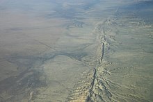
| Aerial photo of the
San Andreas Fault in the Carrizo Plain,
northwest of Los Angeles. |
Earthquakes
An earthquake (or quakes, tremors) is shaking of the
surface of earth, caused by sudden movement in the
Earth's crust. They can be extremely violent.
Earthquakes are usually quite brief, but may repeat.
They are the result of a sudden release of energy in the
Earth's crust. This creates seismic waves, which are
waves of energy that travel through the Earth. The study
of earthquakes is called seismology. Seismology studies
the frequency, type and size of earthquakes over a
period of time.
There are large earthquakes and small earthquakes. Large
earthquakes can take down buildings and cause death and
injury. Earthquakes are measured using observations from
seismometers. The magnitude of an earthquake, and the
intensity of shaking, is usually reported on the Richter
scale. On the scale, 3 or less is scarcely noticeable,
and magnitude 7 (or more) causes damage over a wide
area.
An earthquake under the ocean can cause a tsunami. This
can cause just as much death and destruction as the
earthquake itself. Landslides can happen, too.
Earthquakes are part of the Earth's rock cycle. |
|
Earthquake clusters
Most earthquakes form part of a sequence, related to
each other in terms of location and time. Most
earthquake clusters consist of small tremors which cause
little to no damage, but there is a theory that
earthquakes can recur in a regular pattern.
A foreshock is an earthquake that occurs before a larger
earthquake, called the mainshock. A foreshock is in the
same area of the main shock but always of a smaller
magnitude.
An aftershock is an earthquake that occurs after a
previous earthquake, the mainshock. An aftershock is in
the same region of the main shock but always of a
smaller magnitude. Aftershocks are formed as the crust
adjusts to the effects of the main shock.
Earthquake swarms are sequences of earthquakes striking
in a specific area within a short period of time. They
are different from earthquakes followed by a series of
aftershocks by the fact that no single earthquake in the
sequence is obviously the main shock, therefore none
have notably higher magnitudes than the other. An
example of an earthquake swarm is the 2004 activity at
Yellowstone National Park.
Sometimes a series of earthquakes occur in a sort of
earthquake storm, where the earthquakes strike a fault
in clusters, each triggered by the shaking or stress
redistribution of the previous earthquakes. Similar to
aftershocks but on adjacent segments of fault, these
storms occur over the course of years, and with some of
the later earthquakes as damaging as the early ones.
Such a pattern occurred in the North Anatolian fault in
Turkey in the 20th century.
Tsunami
Tsunami or a chain of fast moving waves in the ocean
caused by powerful earthquakes is a very serious
challenge for people's safety and for earthquake
engineering. Those waves can inundate coastal areas,
destroy houses and even swipe away whole towns.
Unfortunately, tsunamis can not be prevented. However,
there are warning systems which may warn the population
before the big waves reach the land to let them enough
time to rush to safety. |
|
Earthquake-proofing
Some places, such as Japan or California, have many
earthquakes and many inhabitants. There, it is good
practice to construct houses and other buildings which
will resist collapse in an earthquake. This is called
seismic design or "earthquake-proofing".
Earthquake-proof buildings are constructed to withstand
the destructive force of an earthquake. This depends
upon its type of construction, shape, mass distribution,
and rigidity. Different combinations are used. Square,
rectangular, and shell-shaped buildings can withstand
earthquakes better than skyscrapers. To reduce stress, a
building's ground floor can be supported by extremely
rigid, hollow columns, while the rest of the building is
supported by flexible columns inside the hollow columns.
Another method is to use rollers or rubber pads to
separate the base columns from the ground, allowing the
columns to shake parallel to each other during an
earthquake.
To help prevent a roof from collapsing, builders make
the roof out of light-weight materials. Outdoor walls
are made with stronger and more reinforced materials
such as steel or reinforced concrete. During an
earthquake flexible windows may help hold the windows
together so they don’t break. |
|
 Kiddle: Earthquakes Kiddle: Earthquakes
Wikipedia: Earthquakes |
|
|
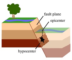 |
| A normal (dip-slip)
fault is an inclined fracture where the rock
mass above an inclined fault moves down. |
The Science of
Earthquakes
What is an earthquake?
An earthquake is what happens when two blocks of the earth
suddenly slip past one another. The surface where they slip
is called the fault or fault plane. The location below the
earth’s surface where the earthquake starts is called the
hypocenter, and the location directly above it on the
surface of the earth is called the epicenter.
Sometimes an earthquake has foreshocks. These are smaller
earthquakes that happen in the same place as the larger
earthquake that follows. Scientists can’t tell that an
earthquake is a foreshock until the larger earthquake
happens. The largest, main earthquake is called the
mainshock. Mainshocks always have aftershocks that follow.
These are smaller earthquakes that occur afterwards in the
same place as the mainshock. Depending on the size of the
mainshock, aftershocks can continue for weeks, months, and
even years after the mainshock! |
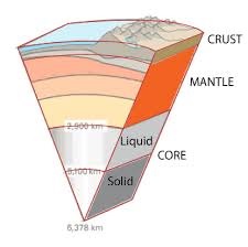 |
| A simplified cartoon
of the crust (brown), mantle (orange), and core
(liquid in light gray, solid in dark gray) of
the earth. |
What causes
earthquakes and where do they happen?
The earth has four major layers: the inner core, outer core,
mantle and crust. The crust and the top of the mantle make
up a thin skin on the surface of our planet.
But this skin is not all in one piece – it is made up of
many pieces like a puzzle covering the surface of the earth.
Not only that, but these puzzle pieces keep slowly moving
around, sliding past one another and bumping into each
other. We call these puzzle pieces tectonic plates, and the
edges of the plates are called the plate boundaries. The
plate boundaries are made up of many faults, and most of the
earthquakes around the world occur on these faults. Since
the edges of the plates are rough, they get stuck while the
rest of the plate keeps moving. Finally, when the plate has
moved far enough, the edges unstick on one of the faults and
there is an earthquake. |
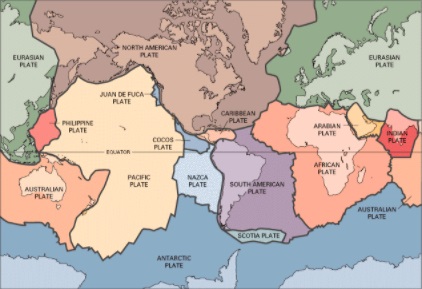 |
| The tectonic plates
divide the Earth's crust into distinct "plates"
that are always slowly moving. Earthquakes are
concentrated along these plate boundaries. |
Why does the
earth shake when there is an earthquake?
While the edges of faults are stuck together, and the rest
of the block is moving, the energy that would normally cause
the blocks to slide past one another is being stored up.
When the force of the moving blocks finally overcomes the
friction of the jagged edges of the fault and it unsticks,
all that stored up energy is released. The energy radiates
outward from the fault in all directions in the form of
seismic waves like ripples on a pond. The seismic waves
shake the earth as they move through it, and when the waves
reach the earth’s surface, they shake the ground and
anything on it, like our houses and us! |
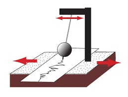 |
| The cartoon sketch
of the seismograph shows how the insrument
shakes with the earth below it, but the
recording device remains stationary (instead of
the other way around). |
How are
earthquakes recorded?
Earthquakes are recorded by instruments called seismographs.
The recording they make is called a seismogram. The
seismograph has a base that sets firmly in the ground, and a
heavy weight that hangs free. When an earthquake causes the
ground to shake, the base of the seismograph shakes too, but
the hanging weight does not. Instead the spring or string
that it is hanging from absorbs all the movement. The
difference in position between the shaking part of the
seismograph and the motionless part is what is recorded.
How do scientists measure the
size of earthquakes?
The size of an earthquake depends on the size of the fault
and the amount of slip on the fault, but that’s not
something scientists can simply measure with a measuring
tape since faults are many kilometers deep beneath the
earth’s surface. So how do they measure an earthquake? They
use the seismogram recordings made on the seismographs at
the surface of the earth to determine how large the
earthquake was. A short wiggly line that doesn’t wiggle very
much means a small earthquake, and a long wiggly line that
wiggles a lot means a large earthquake. The length of the
wiggle depends on the size of the fault, and the size of the
wiggle depends on the amount of slip.
The size of the earthquake is called its magnitude. There is
one magnitude for each earthquake. Scientists also talk
about theintensity of shaking from an earthquake, and this
varies depending on where you are during the earthquake. |
 |
| An example of a
seismic wave with the P wave and S wave labeled. |
How can
scientists tell where the earthquake happened?
Seismograms come in handy for locating earthquakes too, and
being able to see the P wave and the S wave is important.
You learned how P & S waves each shake the ground in
different ways as they travel through it. P waves are also
faster than S waves, and this fact is what allows us to tell
where an earthquake was. To understand how this works, let’s
compare P and S waves to lightning and thunder. Light
travels faster than sound, so during a thunderstorm you will
first see the lightning and then you will hear the thunder.
If you are close to the lightning, the thunder will boom
right after the lightning, but if you are far away from the
lightning, you can count several seconds before you hear the
thunder. The further you are from the storm, the longer it
will take between the lightning and the thunder. |
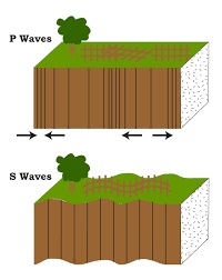 |
| P Waves alternately
compress and stretch the crustal material
parallel to the direction they are propagating.
S Waves cause the crustal material to move back
and forth perpendicular to the direction they
are travelling. |
P waves are like the lightning, and S waves
are like the thunder. The P waves travel faster and shake
the ground where you are first. Then the S waves follow and
shake the ground also. If you are close to the earthquake,
the P and S wave will come one right after the other, but if
you are far away, there will be more time between the two.
By looking at the amount of time between the P and S wave on
a seismogram recorded on a seismograph, scientists can tell
how far away the earthquake was from that location. However,
they can’t tell in what direction from the seismograph the
earthquake was, only how far away it was. If they draw a
circle on a map around the station where the radius of the
circle is the determined distance to the earthquake, they
know the earthquake lies somewhere on the circle. But where?
Scientists then use a method called triangulation to
determine exactly where the earthquake was (see image
below). It is called triangulation because a triangle has
three sides, and it takes three seismographs to locate an
earthquake. If you draw a circle on a map around three
different seismographs where the radius of each is the
distance from that station to the earthquake, the
intersection of those three circles is the epicenter! |
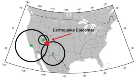 |
| Triangulation can be
used to locate an earthquake. The seismometers
are shown as green dots. The calculated distance
from each seismometer to the earthquake is shown
as a circle. The location where all the circles
intersect is the location of the earthquake
epicenter. |
Can scientists
predict earthquakes?
No, and it is unlikely they will ever be able to predict
them. Scientists have tried many different ways of
predicting earthquakes, but none have been successful. On
any particular fault, scientists know there will be another
earthquake sometime in the future, but they have no way of
telling when it will happen.
Is there such a thing as earthquake
weather? Can some animals or people tell when an earthquake
is about to hit?
These are two questions that do not yet have definite
answers. If weather does affect earthquake occurrence, or if
some animals or people can tell when an earthquake is
coming, we do not yet understand how it works. |
|
|
|