|
|
| |
|
|
| |
|
|
|
|
| |
 Travel
America Travel
America
Learn before you travel. This section of Fun Easy
English focuses on facts and other cool stuff about
your favorite U.S. state. This is great English
reading practice. This page focuses on the state of
Oregon. |
 Hey
if you cannot understand something on this page, Hey
if you cannot understand something on this page,
then use the Fun Easy English
dictionary
(opens in a new window) |
|
|
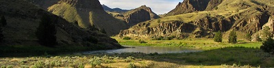
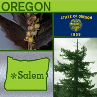 Oregon Oregon
Spanish sailors in search of a northwest passage
were the first Europeans to see what is known today
as Oregon. Settlers traveling in wagon trains over
the Oregon Trail in the 1840s followed the
missionaries who had come in the 1830s. Oregon was
admitted as the 33rd state in 1859. Oregon is a
state of great natural beauty with places such as
Crater Lake National Park and the Columbia River
Gorge. Its mountains, covered in forests, make
Oregon the leading state in the production of wood
products. The state flower is the Oregon grape, and
the capital is Salem. The origin of the state's name
is unknown, but one theory holds that it may have
come from the Wisconsin River, shown in a 1715
French map as "Ouaricon-sint." |
|
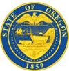
Oregon
State Flag
The Oregon state flag was adopted in 1925 and is the
only U.S. state flag that displays different images on front
and back.
The Oregon flag has gold lettering and symbols on a field of
navy blue (Oregon's state colors). The flag's face displays
part of the state seal and the words "STATE OF OREGON" and
"1859" (the year Oregon was admitted to the Union). The
parade flag (or "dress flag") has a gold fringe, but the
utility flag has a plain border.
The symbols on the shield include the mountains and forests
of Oregon, an elk with branching antlers, a covered wagon
and ox team, the Pacific Ocean with a setting sun, a
departing British man-of-war ship (a symbol of the departure
of British influence in the region) and an arriving American
merchant ship (a symbol of the rise of American power). The
33 stars supporting the shield signify that Oregon was the
33rd state to join the Union.
The reverse of the flag pictures Oregon's official state
animal - the beaver (Oregon's nickname is The Beaver State,
stemming from the early 19th century when fur hats were
fashionable and Oregon’s streams were an important source of
beaver). |
|
Source:
State Symbols USA |
|
|
 Oregon
State Facts Oregon
State Facts
Picture: state seal of Oregon |
|
State Capital |
Salem |
|
Nickname |
Beaver State |
|
Motto |
Alis Volat Propiis (She Flies With Her Own Wings) |
|
Statehood |
February 14, 1859 (33rd) |
|
Origin of Name |
May have been derived from that of the Wisconsin
River shown on a 1715 French map as "Ouaricon-sint." |
|
Largest Cities |
Portland, Eugene, Salem, Gresham, Beaverton |
|
Border States |
California, Idaho, Nevada, Washington |
|
Area |
96,003 sq. mi., 10th largest |
|
State Bird |
Western Meadowlark |
|
State Flower |
Oregon Grape (berberis aquifolium) |
|
State Tree |
Douglas Fir (pseudotsuga menziesii) |
|
State Song |
Oregon, My Oregon |
 Travel and tourism
site for Oregon - This state travel and territorial
tourism site provides ideas for your vacations, meetings, and more. Travel and tourism
site for Oregon - This state travel and territorial
tourism site provides ideas for your vacations, meetings, and more. |
|
|
Oregon Stories |
|
|
Cannon Beach Sand Castle Contest
You may have built a sand castle or two, but have you ever built a
sand castle as elaborate as the one in this photo?
Every year in the small coastal town of Cannon Beach, Oregon, all
sorts of things are made out of sand in the Cannon Beach Sand Castle
Contest: cars, pigs, fish, almost anything you can think of! Most of
the people who enter this contest enjoy building things out of sand
just for fun. Some people, though, are professional sand sculptors
and make a living building things out of sand. They might create a
sand sculpture at a shopping mall, for instance, to promote the mall
and get more people to visit.
The sand castle contest began in August 1965 as a result of a
natural disaster. A year earlier Cannon Beach was hit by a tsunami
(an enormous wave). The tsunami (pronounced "soo-nah-mee") did a lot
of damage to the town, but it also brought a lot of attention to the
area because afterward the lowest tides of the century took place.
Two people decided to hold the sand castle contest to take advantage
of all the media attention.
Today, the contest begins just after the morning high tide and ends
about 12 hours later as the next high tide reclaims the beach -- and
all the beautiful sculptures. Kids of all ages are welcome to
participate. What would your sand castle look like? |
|
|
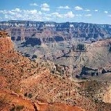
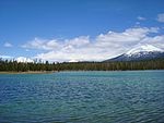
Mount Mazama and Crater Lake
Did you know there was a volcano in Oregon? And that when it erupted
and collapsed it created a lake?
Around 7,000 years ago, the volcano Mount Mazama erupted and
collapsed and, as a result, formed Crater Lake. Molten lava cooled
and sealed up the bottom, forming a huge bowl-shaped crater. Over
the years, rainfall and melting snow have filled it with over four
trillion gallons of water, making it the deepest lake in the United
States. The lake is also known for its deep blue color.
Accounts of the eruption of Mount Mazama are found in stories handed
down by the Klamath Indians, who are descendants of the ancient
Makalak people. According to Makalak legend, there was a battle
between Skell, the spirit of the sky, and Llao, the spirit of the
mountain. When Skell defeated Llao, the spirit of the mountain's
home, Mount Mazama, erupted and collapsed.
Crater Lake is now a national park and draws approximately 500,000
visitors a year. |
|
|
Homowo Festival, Portland, Oregon
For Americans, Thanksgiving Day is a holiday when we give thanks for
all our blessings, including food. In Ghana, Africa, people also
have their own type of Thanksgiving, called Homowo.
Long ago, when the Ga people were traveling across Africa to reach
the continent's western coast, they experienced many hardships,
including great hunger. They traveled for many years, but they
helped each other through difficult times and survived to settle in
what is now known as the country of Ghana. After they settled and
their harvests were plentiful, they had all the food they needed.
They held a harvest festival, called Homowo, that mocked the hunger
that they had suffered during their journey. The word homowo can
mean "hooting or jeering at hunger" in the Ghanian language.
The Homowo festival in Portland, Oregon, is a harvest holiday of
welcoming and thanksgiving, like the one celebrated by the Ga people
of Ghana. The festival began in 1989 as a way for people to share
the traditions of Africa and pass them on to new generations. There
is a lot of joyful dancing and singing and, of course, lots of food! |
|
|
Pacific City Dorying Traditions
In Pacific City, Oregon, people love to go to Cape Kiwanda to watch
the dories. Have you ever seen a dory?
A dory is a flat-bottomed boat, pointed at both the bow (front) and
stern (back) so that it can easily ride the waves. Fishermen first
used dories in New England in the early 1800s. Eventually, fishermen
along the Oregon coast began to use dories, too. Traditionally,
dories were powered by fishermen, who rowed the boat with long oars.
Large fishing ships used to stack dories several boats high on their
decks and when they arrived at a fishing spot, they would send two
to four men out in each dory to catch fish.
Today, many dories have gasoline-powered motors for speed. Each year
in July dory fishermen from the Pacific City area bring out their
dories for a festival called Dory Days. People eat fried fish and
watch the dories, old and new, as they race on Cape Kiwanda. |
|
|
Portland's Chinese New Year
Do you love to see fireworks? The Chinese developed them more than
2,000 years ago. Over the centuries, fireworks have developed into
the colorful and elaborate displays we see today.
Around the world, Chinese New Year is the biggest celebration of the
year for people of Chinese heritage. The date of the Chinese New
Year is based on the cycles of the moon, or the lunar calendar, so
it's often called Lunar New Year. Because of this it doesn't take
place on January 1. It usually occurs about a month later, and in
China it is celebrated for 15 days! The Chinese used firecrackers on
New Year's Eve to send off the old year and welcome the new one.
They also believed that the sound of firecrackers bursting would
help chase away the mythical monster, Nian, who was believed to have
terrorized the people of China.
In the 1850s many Chinese people came to Oregon, when gold was
discovered in the southern part of the state. By the mid-1870s, the
Chinese were the largest ethnic group in Portland. Portland's
Chinese New Year officially begins with a ritual lion dance
performed by musicians and dancers in elaborate costumes. The lion
dance is intended to chase away evil spirits and bring good luck. As
you might imagine, lots of firecrackers are set off during the
celebration, too. |
|
|
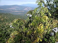
Florence Rhododendron Festival
Do you know what a rhododendron looks like? It is a big bush-like
plant with large and numerous flowers in shades of pink, red, purple
and white.
Rhododendron is the common name for a flowering plant of the heath
family, which has more than 850 species. They are native to the
Himalayas, southeastern Asia, the mountains of Malaysia and the
coast of the Northern Hemisphere. In Florence, Oregon, the beautiful
white-pink plant begins to bloom in May, and by June the surrounding
area is covered with its warm, radiant colors.
The Florence Rhododendron Festival celebrates the arrival of spring.
The pioneers believed that the bloom of the rhododendrons meant that
summer was around the corner and the cold and rain of winter would
soon end. The festival was first held in 1908. Because modes of
transportation have changed since then, the festival has changed
too. To get to the festival back then many people took stagecoaches
pulled by horses; a few years later, they arrived by train on the
new railroad. By the 1940s automobiles were common, and that's how
most people got to Florence. By 1960, automobiles were so popular
that the festival began to feature a show for fancy sports cars.
Another popular event was the motorcycle races. For the past 20
years, "bikers" (the casual name for motorcycle riders) have come to
Florence from all over the West Coast to watch the races and see old
friends. And, of course, they come to enjoy the beautiful
rhododendrons. |
|
|
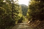
End of the Oregon Trail
Why are those three covered wagons surrounded by a fence? If you
look closer you'll see that they aren't the kind of covered wagons
you can ride in. They are being used as a canopy for the End of the
Oregon Trail Interpretive Center, a museum devoted to the history of
the Oregon Trail.
The Oregon Trail was a route used by people who traveled to Oregon
Country, which is what Oregon was called before it became a state in
1859. The Oregon Trail was the most popular way to get to Oregon
Country from about 1843 through the 1870s. The trail started in
Missouri and covered 2,000 miles before ending in Oregon City.
Most people moving west traveled in covered wagons, which were large
enough for all their belongings as well as the food they needed for
a journey that could take months. The wagons also provided shelter
from the weather. Teams of oxen or mules pulled the wagons along the
dusty trail. People didn't ride in the wagons often, because they
didn't want to wear out their animals. Instead they walked alongside
them, getting just as dusty as the animals. The long journey was
hard on both people and animals. It was even hard on the wagons,
which usually had to be repaired several times during the trip.
To help remember the hardships these pioneers faced, Oregon City
constructed this museum so others could learn about the lives and
experiences of these pioneers. |
|
Source:
Library of Congress |
|
 National
Forests, Parks, and Monuments of Oregon National
Forests, Parks, and Monuments of Oregon
The following is a description of national
forests, parks, and monuments in the state
of Oregon. If you plan to visit or live in
Oregon for awhile then you should definitely
plan to visit some of these fantastic
places. |
|
|
|
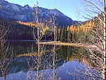
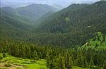
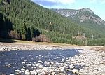
National Forests |
 Deschutes Deschutes
On the east side of the Cascade Range,
Deschutes National Forest includes Newberry
National Volcanic Monument and five
wilderness areas. Lava River Cave, at 5,211
ft (1,588 m) long, is Oregon's longest lava
tube. |
 Fremont-Winema Fremont-Winema
Encompassing the Warner Mountains and
bordering Crater Lake National Park,
Fremont-Winema National Forest also includes
the semi-arid areas of the Oregon Outback.
The Gearhart Mountain Wilderness is near the
center of the forest. |
 Klamath Klamath
Straddling the California-Oregon border,
this forest has part of five wilderness
areas, 152 mi (245 km) of wild and scenic
rivers, and 200 mi (320 km) of rivers for
rafting, including on the Klamath River.The
Siskiyou mariposa lily is endemic to the
forest, being found nowhere else in the
world. This national forest is also
partially located in the state of Oregon. |
 Malheur Malheur
In the Blue Mountains of eastern Oregon,
Malheur National Forest's highest point is
Strawberry Mountain at 9,038 ft (2,755 m).
The Cedar Grove Botanical Area contains the
only stand of Alaska yellow cedar east of
the Cascade Range in the United States. |
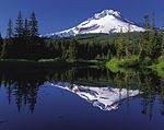 Mount
Hood Mount
Hood
This forest is named for and contains Mount
Hood, the highest point in Oregon at 11,249
ft (3,429 m). The forest stretches from the
Columbia River Gorge and includes Mount Hood
National Recreation Area and nine wilderness
areas. |
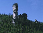 Ochoco Ochoco
Ochoco National Forest contains a variety of
odd geological formations, 95,000 acres
(38,000 ha) of old-growth forest, the
headwaters of the Crooked River, and three
wilderness areas. Stein's Pillar is a 350 ft
(110 m) tall rock column in the Ochoco
Mountains. |
 Rogue
River-Siskiyou Rogue
River-Siskiyou
This forest ranges from the Cascade Range to
the Siskiyou Mountains, and the Rogue River
drains over 75% of the forest's area. There
are parts of eight wilderness areas in the
forest as well as what may be the world's
tallest pine tree, a ponderosa pine that is
268.35 ft (81.79 m) tall. This national
forest is also partially located in the
state of California. |
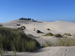 Siuslaw Siuslaw
Siuslaw National Forest includes Oregon
Dunes National Recreation Area, three
wilderness areas, and Cascade Head Scenic
Research Area among the Central Oregon Coast
Range. Marys Peak Scenic Botanical Area
includes Marys Peak, which at 4,097 ft
(1,249 m) is the forest's highest point. |
 Umatilla Umatilla
Located in the Blue Mountains of
northeastern Oregon, Umatilla National
Forest includes three wilderness areas,
occupying over 20% of the forest. The forest
has over 715 mi (1,151 km) of trails, 2,000
mi (3,200 km) of roads, and one of the
largest elk herds of any National Forest.
This national forest is also partially
located in the state of Washington. |
 Umpqua Umpqua
Umpqua National Forest is in the Cascade
Range of southwestern Oregon and includes
three wilderness areas. Watson Falls is a
waterfall that is 272 ft (83 m) high on
Watson Creek, a tributary of the Clearwater
River. |
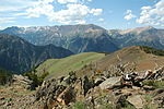 Wallowa-Whitman Wallowa-Whitman
Wallowa-Whitman National Forest stretches
from the Blue Mountains to the Snake River.
Elevations range from 875 ft (267 m) in
Hells Canyon, the deepest gorge in North
America, to 9,845 ft (3,001 m) at the summit
of Sacajawea Peak in the Eagle Cap
Wilderness Area. This national forest is
also partially located in the state of
Idaho. |
 Willamette Willamette
Willamette National Forest is in the Cascade
Range, stretching from Mount Jefferson to
Mount Washington. About 20% of the forest is
designated wilderness, but there are also
6,000 mi (9,700 km) of roads in the forest. |
|
|
|
National Parks |
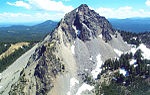
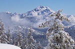
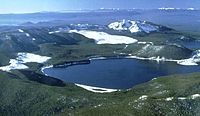
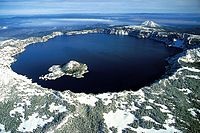 Crater
Lake Crater
Lake
Crater Lake lies in the caldera of an
ancient volcano called Mount Mazama that
collapsed 7,700 years ago. The lake is the
deepest in the United States and is noted
for its vivid blue color and water clarity.
Wizard Island and the Phantom Ship are more
recent volcanic formations within the
caldera. As the lake has no inlets or
outlets, the lake is replenished only by
precipitation. |
|
|
|
National Monuments |
 Cascade–Siskiyou Cascade–Siskiyou
One of the most diverse ecosystems found in
the Cascade Range, it has more than 100
dwelling and root-gathering sites belonging
to the Modoc, Klamath, and Shasta tribes.
This national monument is also partially
located in the state of California. |
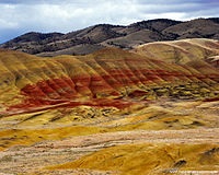 John
Day Fossil Beds John
Day Fossil Beds
Located within the John Day River Basin, the
Fossil Beds have a well-preserved, complete
record of fossil plants and animals from
more than 40 of the 65 million years of the
Cenozoic Era. The monument is divided into
three units: Painted Hills, named for its
delicately colored stratifications; Sheep
Rock; and Clarno. Blue Basin is a volcanic
ash bowl transformed into claystone by eons
of erosion, colored pastel blue by minerals. |
 Newberry Newberry
Located within Deschutes National Forest,
the monument protects the area around the
Newberry Volcano and its geologic features.
It contains over 50,000 acres (200 km2) of
lakes, lava flows, and other geologic
features. |
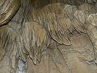 Oregon
Caves Oregon
Caves
The monument is known for its marble caves,
as well as for the Pleistocene jaguar and
grizzly bear fossils found in the deeper
caves. There are four primary buildings: The
Oregon Caves Chateau, The Ranger Residence,
The Chalet, and the old Dormitory. |
|
|
|
|
|
|
|
|
|
|
|
|
Cool America |
 About the U.S.A. About the U.S.A.
About the U.S.A. is an American
Studies reader that examines the customs, government, and history of the
United States of America. The text provides a wealth of information on U.S.
geography and history; the roles of local, state, and federal government;
national holidays and symbols; the Constitution; and citizenship. The book,
which was written for intermediate to advanced learners of English, contains
a range of activities for language students to practice listening, speaking,
reading, and writing. (opens to a new PDF window)
Great English reading
practice. |
 About
America About
America
Learn about the fascinating history and government of
the United States of America. Lessons include content on
American Government, American History, and Integrated
Civics. Handouts with interactive games and
student-centered activities encompass all four language
skills: speaking, listening, reading, and writing.
Great English reading practice for
beginning to intermediate students. |
 American Teens Talk! American Teens Talk!
Americans Teens Talk! is a collection of interviews of
American high school students. Each interview is accompanied by vocabulary
notes and discussion questions. The interviews in American Teens Talk! give
learners a view into the lives of adolescents in the U.S. Through the
written format of the interviews, learners are able to increase their
vocabulary, practice their reading and listening skills, engage in
discussions, and learn more about U.S. culture. These
interviews come with audio programs.
Great English listening and
reading |
 Sing Out Loud Children's Songs Sing Out Loud Children's Songs
Sing Out Loud Children's Songs includes popular children's songs in the U.S.A. Posters accompany the
individual Sing Out Loud Children's Songs. These
songs come with audio programs.
Great English listening and reading
practice. |
 Sing Out Loud Traditional Songs Sing Out Loud Traditional Songs
The Sing Out Loud Traditional Songs
collection contains 13 traditional American folk songs and song lyrics.
Listen to the songs online, read the lyrics, and collect the posters that
accompany the songs. These
songs come with audio programs.
Great English listening and reading
practice. |
 Sing Out Loud American Rhythms Sing Out Loud American Rhythms
Do you love music? Want to use it
to learn English? Check out the hip-hop inspired song "Peace" from Sing Out
Loud American Rhythms. American Rhythms includes a variety of musical genres
from many different artists in the U.S.A. These songs will appeal to teens
and young adults. These
songs come with audio programs.
Great English listening and reading
practice. |
 Route
66 - Famous American Road Route
66 - Famous American Road
U.S. Route 66 (US 66 or Route 66), also known as the Will Rogers Highway, the
Main Street of America or the Mother Road, was one of the original highways in
the U.S. Highway System. The highway, which became one of the most famous roads
in the United States, originally ran from Chicago, Illinois, through Missouri,
Kansas, Oklahoma, Texas, New Mexico, and Arizona before ending in Santa Monica,
California, near Los Angeles, covering a total of 2,448 miles (3,940 km). It was
recognized in popular culture by both the hit song "(Get Your Kicks on) Route
66" and the Route 66 television show in the 1960s. |
Route 66: The Highway That's the Best
(Beginner - Listening)
A video lesson which shows you an interesting place in America.
The English is
spoken at 75% of normal speed.
Great English listening practice.
This video shows travel along Route 66, the most famous road in
America. |
Chicago: The Start of Route 66
(Beginner - Listening)
A video lesson which shows you an interesting place in America.
The English is
spoken at 75% of normal speed.
Great English listening practice.
This video shows travel along Route 66, the most famous road in
America. |
Going West for Decades on Route 66
(Beginner - Listening)
A video lesson which shows you an interesting place in America.
The English is
spoken at 75% of normal speed.
Great English listening practice.
This video shows travel along Route 66, the most famous road in
America. |
Arizona: The Spirit of Route 66
(Beginner - Listening)
A video lesson which shows you an interesting place in America.
The English is
spoken at 75% of normal speed.
Great English listening practice.
This video shows travel along Route 66, the most famous road in
America. |
Route 66 California: The End of the Trail
(Beginner - Listening)
A video lesson which shows you an interesting place in America.
The English is
spoken at 75% of normal speed.
Great English listening practice.
This video shows travel along Route 66, the most famous road in
America. |
Ten Must-See Route 66 Attractions
(Beginner - Listening)
A video lesson which shows you an interesting place in America.
The English is
spoken at 75% of normal speed.
Great English listening practice.
This video shows travel along Route 66, the most famous road in
America. |
Four Famous Foods On Route 66
(Beginner - Listening)
A video lesson which shows you an interesting place in America.
The English is
spoken at 75% of normal speed.
Great English listening practice.
This video shows travel along Route 66, the most famous road in
America. |
International Tourists Drawn to Route 66
(Beginner - Listening)
A video lesson which shows you an interesting place in America.
The English is
spoken at 75% of normal speed.
Great English listening practice.
This video shows travel along Route 66, the most famous road in
America. |
|
|
|
|
Search Fun Easy English |
|
|
|
|
|
|
|
|
|
|
|
|
|
|
|
About
Contact
Copyright
Resources
Site Map |

